| |
THE BIRTH OF A HYPOTHESIS:
MOUNT SINAI EXODUS AT HAR KARKOM
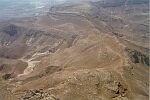
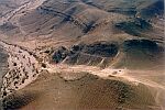
A mountain of sanctuaries in the heart of the desert of Exodus should have quickly suggested biblical parallels. Although the archaeologically and historically relevant character of Har Karkom as a Bronze Age holy mountain was immediately evident, at first no relation was considered between this high place and Mount Sinai. Until our Har Karkom research, no reasonable doubt met the conventional belief that the Exodus as described in the Bible occurred in the thirteenth century BC, and that the biblical Mount Sinai was the mountain at whose foot the Byzantine Monastery of Saint Catherine was built. For us, like for many people, these were established and consolidated traditions. In fact, however, the surroundings of Saint Catherine show no traces of cult activity from periods prior to the Byzantine.
Many scholars today are convinced that the geography of the biblical narrative locates Mount Sinai in the north of the peninsula rather than in the south, but we had never faced the problem before. On the other hand, no remnants of human presence belonging to the thirteenth century BC are found at Har Karkom. The date usually attributed to the Exodus coincides with the middle of a long hiatus of archaeological evidence at Har Karkom. Therefore, if indeed the thirteenth century must be the date of the Exodus, Har Karkom could hardly have been Mount Sinai.
Today we know that this hiatus encompasses most of the Sinai Peninsula and the Negev desert, the only exceptions being military stations, trading posts along established routes and mining centres run by the state. Therefore the hiatus is not a peculiarity of Har Karkom. The Bible describes the daily life of different peoples living in the desert at the time of the Exodus. If the biblical narration is rooted in some base of historical memory, the Exodus should have taken place in a period when people like Midianites, Amalekites, Edomites, Amorites, Horites, and other tribes lived in the region through which the Israelites journeyed.
Only two possibilities remain, then: either the entire story and the description of all these people is simply a mythological invention, or the evidence described and the people referred to must have belonged to a period in which tribal life existed in these areas, other than the second millennium BC. According to palaeo-climatic and archaeological evidence, such dynamic tribal life in this area could not belong to the second millennium BC, but in the first years of the Har Karkom expeditions we did not have this information. Neither did we have these queries.
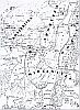
Another factor that at first excluded any consideration of a relationship between Har Karkom and the Exodus was the geographical position of this mountain near the biblical borders of the "Promised Land". The borders of the "Promised Land" are described in the book of Numbers: "the Negev quarter shall be from the wilderness of Zin along by the border of Edom, and your south border shall be the outmost coast of the Dead Sea eastward: and your border shall turn from the Negev to Akrabbim and pass on to Zin, and its limits shall be south to Kadesh-barnea, and shall go on to Hazar-addar, and pass on to Azmon: and the border shall turn about, from Azmon to the wadi of Egypt, and its limits shall be the sea" (Numbers 34:3-5). The line which is traced by this description crosses to the north of Har Karkom. The border unites the south end of the Dead Sea with the Akrabbim trail, and the Desert of Zin to Kadesh-barnea, and the River of Egypt, which is Wadi El-Arish, to the Mediterranean Sea approximately where the city of El-Arish is located today.
Mount Sinai is frequently seen in the literature as a distant site. Har Karkom dominates the area called Desert Paran, in what the book of Numbers defines as the land of Edom, but it is not part of any previously proposed itinerary of Exodus. A serious mental effort was required to imagine that these old authoritative maps of the desert stations of the Israelites could have been imprecise. Comparing, however, the different itineraries described in the books, historical atlases, and old maps, it did appear that the propositions differed broadly. Scholars and travellers apparently agreed on the location of only a few of the sites, such as Kadesh-barnea in the area of the oasis of Ein-Kudeirat, or Ezion-geber on the shores of the Red Sea near present-day Eilat. On the other hand all the Pentateuch texts in which Mount Sinai is mentioned seem to show a coherent and constant notion of its geographical location. One gathers the impression that whoever wrote or transcribed those descriptions knew what they were talking about. They knew where to locate Mount Sinai.
The story of Exodus and the revelation of Moses on Mount Sinai have a compelling ethical appeal. The crossing of the desert and the revelation are the prototype of a universal transition rite through which an entire people gained adulthood, freedom, and a new identity. The march toward the "Promised Land" is an archetype of myths of origin, with analogies among various populations on four continents. A vast literature of historical reconstruction, interpretation, and evaluation has come to life in the last two thousand years, often constituted by an accumulation of notions, scholastic approaches, and preconceived ideas much more than by the analysis of the topographic reality of the concerned territory. If we accept that the Bible may communicate the memory of a real mountain, the location of Mount Sinai in the area of Saint Catherine is certainly wrong, as it does not correspond in any way to the several biblical descriptions which locate the mountain topographically and geographically in a territory surrounded by named and defined deserts and tribal areas of specific ethnic groups.
We do not know why the original position of the Mountain of God was not preserved in the collective memory. One should not exclude that this is partially due to the recurrent, strict prohibition in biblical texts from visiting the mountain. Attempts to locate the mountain in the area of Saint Catherine only go back to the Byzantine period, more than a millennium after the prophet Elijah is said to have visited the mountain, and an even longer time after the stories of Moses and the Exodus were recounted. The Byzantine identification of a mountain in the area of Saint Catherine has left many doubts, and the search for the true location of Mount Sinai has since occupied explorers, archaeologists, and theologians alike.
Going deep into a study of this riddle, we discovered that more than twenty mountains are candidates for identification as the biblical Mount Sinai. Experts approach the issue in a variety of ways. Some scholars have concluded that the entire story of the Exodus must have been nothing but an invented myth, an imaginary tale. Such a hypothesis seems to us a simplistic solution that is contradicted by details of the biblical text itself: some sites are located and described in specific terms, and some locations of the itinerary are noted so that the people to whom the text was addressed would be able to recognise the routes. An ethnographic analysis of the biblical texts seems to emphasise that their standard process of formation facilitates the memorising of genealogies and other stories in tribal non-literate societies. Basic essential elements include the precise memorising of geographical information which may be checked by every member of the tribe.
Other scholars considered the itinerary as a sequence or succession of casual movements from one well to another, so that the list of stopping places was a sort of litany of magic words rather than meaningful topographical information. We shall demonstrate in the following pages that such hypotheses are lacking in validity. Again, another group of biblical scholars believes that the whole story of Exodus was invented at the time of the Babylonian captivity for didactic purposes to indoctrinate the generations who were preparing for a return to the "Promised Land." In such case, the proposed historical process of acquisition of a historical tradition would clash with all that we know about the processes of historicization. Further, in the narration of Exodus, as well as in that of Joshua, fragments of texts in an archaic language are inserted into the compilation. This may provide some clues to a process of textual assemblage reflecting several centuries of accumulation.
Some scholars have considered the possibility that the desert wanderings of the children of Israel was a journey covering the whole peninsula, from the land of Goshen in the Nile Delta region, to Jebel-Musa in the south near the Byzantine monastery of Saint Catherine, and from there to the oasis of Ein-Kudeirat (believed to be the site of Kadesh-barnea) in the north. Yet another group of scholars suggested the hypothesis that the Exodus itinerary described sites along the Mediterranean coast in the north of the Sinai parallel to the "Via Maris", the "road to the land of the Philistines," which in historical times has always been the main route between Africa and Asia. Yet another reading sees the sequence of stations as nothing more than a list of wells along a desert path that was in use at the time of compilation. Most of these approaches seem to show intent to discredit the historical value of the biblical narration. In our view they do not rely on solid scientific reasoning, nor do they have serious exegetic or theological motivations. In any case recent archaeological discoveries, specifically at Har Karkom, demand a reconsideration of all these hypotheses.
Those asserting that the biblical narration of Exodus is just a fairy tale are obviously not compelled to search out topography to match the text. Those who start their topographical analysis with the preconception that Mount Sinai is located at the area of Saint Catherine, or in any other site in the south or central part of the Sinai Peninsula, will find it impossible to make topographical or geographical sense of the sequence of stations. They will also find it impossible to geographically determine a map of tribes and deserts, repeated in various books of the Bible, in such a way as not to contradict any of the biblical descriptions. In any case, when the itinerary was compiled in the first millennium BC the route described must have been topographically acceptable to the populations who were familiar with the region, to whom the narration was addressed.
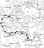
In 1989 and again in 1992, we put various hypotheses concerning the itinerary of the Exodus to field examinations by following ancient trails from the Nile Delta through the various regions of Egyptian Sinai, the Israeli Negev and Jordan, visiting wells and ancient sites on the way. Earlier, with entirely different purposes, we had done archaeological surveys in these areas dealing with rock art and prehistoric sites. After years of our wanderings in the desert it was somehow surprising to discover that places we had visited before - the trails, mountains, valleys, wells, and remains of ancient settlements - acquired new dimensions. Desert archaeology has indeed many facets according to the specific interest of the archaeologist.
In our view the list of stations in the biblical narration of Exodus makes geographical sense, and with our investigations we verified that several descriptions of these stations could be identified with sites in the field. Sometimes the biblical texts describe details that can still be recognised today. Occasionally even the names have been preserved. (This subject is considered in another book: E. Anati, Esodo tra Mito e Storia, 1997.)
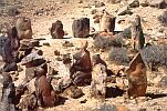
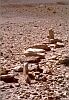
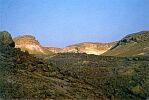
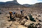
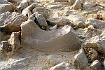
After four years of field work on the mountain, after the discovery of numerous cult structures that demonstrated Har Karkom's role as a paramount cult place, and on the basis of topographical and archaeological evidence, we proposed the identification of Har Karkom with the sacred Sinai of the Bible. In the years that have since elapsed, fieldwork has progressed, new discoveries have been made, and we have become even more convinced that our tentative hypothesis has a justifiable basis. In consideration of the striking similarity between the topographical and geographical descriptions of the Bible with those of the archaeological context at Har Karkom, we can now affirm that the compilers of the biblical narration had this mountain in mind when they described Mount Sinai. This alone, of course, does not prove that the events in the Bible did, indeed, take place.
Taking into consideration the topography emerging from the biblical narration, C.S. Jarvis (1938), B. Mazar (1981) and other scholars had already proposed that Mount Sinai should be located in the north of the Sinai Peninsula. However, the identification of a specific mountain that ties in with pertinent archaeological finds and topographical descriptions scandalised the academic world. At first our idea was rejected by the majority of scholars, but it stimulated a vast debate. The reaction of some colleagues was that both the field work and the debate should continue until a conclusion emerged. Others pressured us to discontinue our research because they decided that Mount Sinai was nothing but a mythical locale.
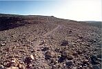
On one side, some simply accepted popular beliefs on Mount Sinai's location. Their comments can be summed up as follows: "Everybody knows that Jebel-Musa is Mount Sinai, so there is no reason this discussion should go any further"; "Mount Sinai must be the highest mountain on the peninsula"; or "Since the burning bush is near the Monastery of Saint Catherine, the mountain cannot be far away from there." Such preconceived approaches are vulnerable to theological, geographical, historical, and archaeological investigations alike. Others claimed that "a group of nomads in the desert would not leave traces." This statement is simply incorrect. At Har Karkom and in other areas of the Negev and the Sinai we have located traces of numerous nomadic camping sites from Palaeolithic times through the Islamic period but none in the late Bronze Age.
Other scholars do not agree with the chronology that has emerged from our finds at Har Karkom. They claim, "Since the Exodus took place in the thirteenth century BC, Mount Sinai should have camping sites of the thirteenth century at its foot." If this dating was as certain as some believe, the same rule should apply to every site that is a candidate for Mount Sinai, not only to Har Karkom. In such a case not a single mountain in the Sinai Peninsula would be suitable, since the thirteenth century is in the middle of a long hiatus in the archaeological sequence (see chart).
It is not easy to navigate against such contrary winds. Faith, in some cases, makes knowledge unnecessary if not annoying. And making people change their faith may be more difficult than making them defend obsolete or preconceived ideas.
Potential sponsors were requested not to support our research, which caused damage to moral as well as financial resources. Some colleagues even came to us to ask us to abandon this course of research altogether. All this led us to ask ourselves, day after day, what was astray in our reasoning. Of course doubts exist, they are the nourishment of research. However, these doubts are not a valid motive for abandoning the research; on the contrary, they have increased our motivation to continue.
We have been invited to many universities and study centres in Europe, the United States, and Israel to lecture on this research, frequently in an attempt to demonstrate that we were on the wrong trail. In most cases, however, the result was exactly the opposite, and we proved time after time that no serious arguments stood in the way of our ideas. After one of these lectures, an eminent biblicist came to us and said, "I have been teaching for over thirty years that Jebel-Musa is Mount Sinai. How can you expect me to change my position at my age?" With all the goodwill to keep our minds open to every proposal and option, this question brought to mind an old proverb: "A lie repeated a hundred times is more believable than a truth said for the first time." But what is truth? If truth relies on faith, it does not need proof, and further, any proof that contradicts that official truth can then be considered a heresy. We discovered that some schools of scientific research practise a faith in their own convictions.
According to the best of our knowledge, except for the Greek Orthodox Church which until very recently retained the belief that the biblical Mount Sinai is the peak above the Monastery of Saint Catherine, no religious denomination has taken a position regarding the location of Mount Sinai. The debate with theologians, biblical scholars, and archaeologists may remain open. Meanwhile, the immense concentration of cult sites at Har Karkom demonstrates that it was a major cult centre, a sacred mountain. No other similar context has yet been found in the case of any other "candidate" for identification with Mount Sinai. The topography of Har Karkom appears to correspond to that of the biblical Mount Sinai; again, such correspondence has never before been found in another place. Every year new archaeological data accumulates and reveals more and more detail of what happened on this mountain over the course of millennia. Research is still in progress, and the story of this mountain becomes increasingly detailed and complex. But already the topography of the area, the cult sites found on the mountain and the camping sites at its foot provide a significant and unique cluster of data, as we shall see in the following chapters.
|
 Get the book for only 15. (you save 10.)