| |
THE HUMAN LANDSCAPE:
CAMPING SITES AND OTHER STRUCTURES FROM THE BRONZE AGE
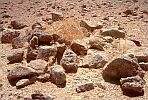
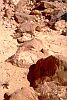
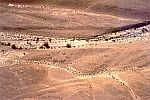
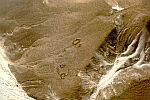
The valleys surrounding Har Karkom contain numerous remains of camping sites and hamlets. From the different kinds of living structures it may be inferred that several tribes came to camp at the foot of the mountain in the BAC period. Who were they? There are various ways of answering this question. One is to attempt an identification of tribes described in the Bible, which we shall let the reader do. A geographical distribution of each type of site in comparison to other areas of the Sinai and of the Near East may provide some general views on the historical and geographical background of these various groups. But the main answer we want to give is an archaeological one - other interpretations may follow thereafter. From the findings, deductions can be made about the character, social structure, economy and beliefs of these human groups. Most of the sites with stone foundations from the BAC period usually present a similar type of material culture, with a wealth of flint implements and scanty pottery finds that belong to the same general period as the cult sites.
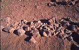
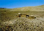
The remains indicate the presence of villages where groups of people settled long enough to justify the construction and the occasional repair of walls and floors. Different types of living structures have been found, but all have low stone walls, probably reaching an average height of 1 to 1.5 meters, which are likely to have supported roofs of woven mats, skins, or other organic material. According to the expedition's architect, Gigi Cottinelli, the two main elements from which people needed protection were sun and wind. Rain may have forced them to shelter for only a short "season" of a few days a year. Against heat the only means of relief was the provision of as much ventilation as possible.
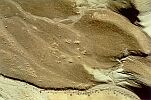
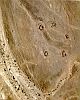
In the area of concession over three hundred BAC sites have been recorded, well over half of which are found in the specific area surrounding Har Karkom. Many of these 187 sites have been identified as living sites, with an average of 20 to 30 structures each. Rather consistently human groups built their habitations at the foot of the mountain or in its immediate vicinity. Why just here? The region offers meagre material resources, and today it is completely empty of population. In 1954, when we first visited the area there were a few scattered Bedouin tents, mainly near Beer Karkom, and a total of less than 60 people, in 200 sq. km. Even if the climate was somewhat less severe in the BAC period, it is hard to conceive how so many Bronze Age people could find adequate resources for their survival.
Cult sites are primarily concentrated on the mountain's heights while living sites are at its base, though cult sites also exist in and near the living sites. From a comparative analysis with other explored areas of the Negev, it emerges that the number of BAC living sites at Har Karkom are about double other areas, despite the greater fertility and the more abundant economic resources of many other places in the region. From what we know today, the quantity of cult sites at Har Karkom is a unique and exclusive feature of this specific area.
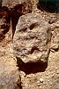
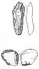
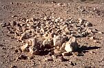
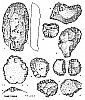
What do we find in the structures and in the courtyards? Simple tools of daily use are the most common remnants of the ancient peoples. Primarily these findings of material culture are flint implements, but only a small number of them are tools in a conventional sense. They include retouched blades and points, knives with blunted backs, several denticulate tools, and scrapers, many of which can be classified as fan scrapers. Most of them are tools for working with wood, skin, and bone, which help illustrate the craft connected with pastoral and agricultural lifestyle. Also found were axes and herminets with bifacial retouching, which in rare cases were polished. Typically pedunculated arrowheads are scarce; some of the flint points, however, may have been used as arrowheads. The lithic industry is characteristic of the Negev and Sinai Chalcolithic Age, and it persisted into the early Bronze Age. A surprising number of flakes from the Palaeolithic Age have been collected, retrimmed, and reused in the BAC period. The BAC retouches have a different shade of patina and are easily recognisable. With the exception of a few sporadic cases of tools with particularly elegant, Egyptian-like "expanded" retouches, and some particularly handsome knifes and fan scrapers, the bulk of products from this lithic industry are not notably refined.
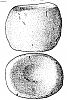
The majority of ceramic findings consist of small shards which have been identified by a group of experts, led by Rudolph Cohen of the Antiquities Authority, as belonging to two phases: the second phase of the early Bronze Age corresponding to the Second Egyptian Dynasty (2890-2686 BC), and the initial phase of the middle Bronze Age corresponding to the First Intermediate Period in Egypt (circa 2180-2040 BC). Further, some early pottery may be a product either of the Chalcolithic or early Bronze Age. The pottery forms, largely bowls and hole-mouth jars, are generally little diversified, and the clay is of a rough quality. The vessels have large, flat bases, and most do not seem to have handles, though examples of plain-ledge handles have been found. Some of the jars show similarity to those from the late Chalcolithic period found at Beer-Sheba, but the poor quality of material and manufacture, the monotony of shapes, and the lack of decoration are indicative of a culture poor in material wealth. One gathers the impression that other vessels may have been made of organic material, such as skin, wood or dried calabash, which were not preserved.
On the whole, the lithic industry as shown by these living sites is of Chalcolithic tradition, accompanied by pottery with parallels in the final Chalcolithic, in the early Bronze Age, and in the initial phases of the middle Bronze Age. Such material culture appears to reflect a local Chalcolithic tradition which persisted until the beginning of the middle Bronze Age.
As a working hypothesis it is suggested that the BAC period began in the fifth millennium BC and spread into the fourth and third millenniums BC. The whole period was divided into four phases: the initial phase is BAC-I, tentatively dated to 4500-3400 BC. The greatest density of sites refers to two phases which are intercalated by what seems to be an archaeological semi-hiatus: BAC-II spans 3400-2600 BC, BAC-III seems to be a semi-hiatus dry period from 2600 to 2350; and BAC-IV spans 2350-2000 BC. The BAC period comes to an end with the abandonment of the area by semi-permanent populations between 2000 and 1950 BC.
As far as the historical general background is concerned, we know that in the course of phases I and II of the early Bronze Age (roughly corresponding with BAC-II) strong cultural influences from Mesopotamia and Northern Syria press toward the Syro-Palestinian area and Egypt. New ceramic shapes, decoration, and iconography seem to indicate the southward expansion of Mesopotamian elements. This may well correspond to a new wave of building fortified cities on the edge of the fertile areas, such as the sites of Bab ed-Dhra, Ai, and Arad.
The second period of intense human presence at Har Karkom is phase BAC-IV corresponding to the final early Bronze Age and the beginning of the middle Bronze Age in the Syro-Palestinian area. In Egypt this was the time of the Sixth Dynasty (2345-2184) and of the First Intermediate Period (2180-2040 BC). The Negev and Sinai, the south of Jordan, and the southern strip of the Palestinian area reveal contacts with Egypt, mainly in connection with the exploitation of mining resources. At Har Karkom flint implements with peculiar, flat retouching, show similarities to contemporary Egyptian implements, while at Beer Karkom a small, alabaster jar of Egyptian origin was found.
This period seems to have brought movements of populations: nomadic tribes moved from Egypt to the periphery of Palestine. Farther north a completely different movement of people, likely to be of northern roots, is recorded, of tribes who built dolmen and other megalithic monuments in Syria and in the Golan Heights during this period. Meanwhile southern Jordan was the location of a quick and brief colonisation of a different kind. The peripheral areas reveal an intense life of various kinds of human groups.
In the fertile areas many fortified cities were destroyed as the result of incursions of peripheral peoples. The political frame of the Near East was unstable; in the desert we see an increase in living sites that persisted in a traditional and introverted way of life with Egyptian influence. This lasted until the phase of drought that brought about the total desertification of the southern deserts and their subsequent abandonment.
From the stone structures recorded at Har Karkom, it seems that several living sites were semi-permanent and were reutilized more than once, perhaps with seasonal fluctuations in occupation. In many sites the typical pottery attributed to the early Bronze Age has been collected in the same rooms and courtyards as pottery attributed to the beginning of the middle Bronze Age. One gathers the impression that the ceramic shapes attributed to the early phase of the middle Bronze Age may have appeared before, tentatively in the semi-arid phase of BAC-III. In such a case, these patterns may have become established here earlier than in the fertile areas.
Palaeoclimatologists identified some brief, dry episodes between 2600 and 2300 BC that may have caused temporary abandonment of the arid zones, as emphasised in two separate studies by A. Isaar (1995) and M. Bar-Matthews (1998). Such episodes are likely to correspond to semi-hiatus phase BAC-III. One may theoretically speculate on whether these dry spells could synchronise with historical or mythic events preceding the Exodus in biblical narration. Genesis refers to at least two periods of drought, the first when Abraham went to Egypt because of famine (Genesis 12:10), and the other when Jacob's family reached the land of Goshen (Genesis 41:57). No doubt the Nile Valley was a source of sustenance for the desert nomads in periods of famine. At the time before the Sixth Dynasty, the Egyptians were welcoming Asiatic tribes, marketing their wheat and other staple foods in moments of shortage elsewhere. Here again biblical narration may well have been inspired by memories of real events.
At Har Karkom the living sites reflect the habits of peripheral communities. The typology of the structures found in the different localities show a variety of types, each with recurring patterns. The various structures illustrate the presence of different populations for relatively long periods of time: some nomadic or semi-nomadic, others semi-sedentary. The Chalcolithic typology of most of the lithic industry seems to indicate a cultural environment belonging to the fourth millennium BC, but probably starting before and persisting thereafter. In fact, according to the experts' evaluations, most of the pottery found in the same context belongs to the third millennium BC. We may therefore visualise a mosaic of marginal groups at the periphery of the fertile zones with a persistence of over two millennia. This is the type of material culture which we refer to as BAC, or Bronze Age Complex.
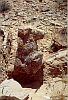
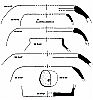
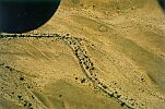
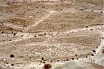
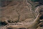
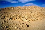
The most common type of structure of the BAC period has been named the "courtyard structure." It consists of stone foundations of large round or oval courtyards with small rooms around them. Often near a major courtyard are smaller ones. Such accumulation of walls and enclosures seems to indicate that each complex has been used for several generations. If we may compare such sites with the ethnographic examples of the Masai and other African populations that still live in villages with comparable plans, these settlements could reflect semi-nomadic pastoral groups that maintain the property of their sites and return to them seasonally for generations; the simple enclosures within the settlements emphasise their pastoral nature.
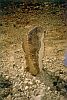
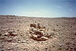
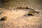
Just outside the cluster of huts and enclosures, sometimes a natural monolith or large boulder is surrounded by a stone circle and heaps of stones. These may reflect something similar to what the Bible calls Gal-ed, or heaps of testimony, near which contracts or agreements were reached, or where elders met in a sort of local court. In some cases, near these monoliths, alignments of orthostats are found. Other tumuli found around these settlements may have had a funerary use.
The courtyard structures appear to be semi-permanent, seasonal settlements where people returned year after year. They suggest the presence of clan groups that moved with animals and people. Usually a larger courtyard had several smaller ones built around it in a diameter of up to four hundred meters, perhaps showing a physical representation of social structure. This sort of housing arrangement might result from a strong "patriarchal model" of several families grouped around a main household, perhaps of the father or the leader. In the Bible the classical reference to such a patriarchal figure is Abraham, whose name literally signifies "high father" (ab = father, ram = high or great). A predominance of animal enclosures shows that the economy of the courtyard sites was based on animal husbandry but evidence of field clearing seems to testify also the presence of limited garden agriculture. In the area of Har Karkom, remains of primitive agricultural terracing near several of these sites are likely to belong to the same age and indicate the presence of small agricultural fields. The courtyard structures are typical of the older phases of BAC (I and II), but in a few cases they seem to have remained in use successively.
The BAC terraces are distinct from later ones in their building technique: usually they are formed by rows of boulders, and the choice of cultivable land is between the wadis on the mild lateral slopes and the semi-flat areas. Nabatean and other Hellenistic, Roman, and Byzantine terraces are located on the side terraces of wadis and are built with smaller stones. The technique of building field terraces varies then in three phases: Hellenistic-Nabatean, late Roman and Byzantine and Islamic. The technique of the BAC terraces is consistently different from all of these.
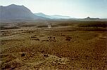
Hamlet sites are a second type of BAC habitation characterised by the agglomeration of stone structures near each other that may include between ten and forty rooms and smaller courtyards. Hamlet sites have no main, central courtyard; rather they are distinct because of the remains of threshing floors around the settlement. Here again tumuli, standing monoliths, and paved platforms, some with an altar-like structure oriented eastward, can be found near the settlements. This type of settlement seems to have been more permanent than the previous ones and may have been in use all year round. The threshing floors probably indicate the tilling of wheat, and the presence of small rooms that could have stored grain also suggest the agricultural nature of such settlements. Similar living sites are known in the Uvda Valley south of Har Karkom, near the Arabah Valley, and it has been suggested that they may reflect a way of life similar to that of the Midianites as described in the Bible. On the basis of the material remains at Har Karkom, these sites were mainly active in the late phases of the BAC period (IV), thus in the transition phase from the early to the middle Bronze Age and at the beginning of the middle Bronze Age.
A third type of living site are called Row Sites. They consist of rows of small living structures in oval or circular shapes, or with irregular angles. The planning of these sites, with the alignment of the living structures, seems to reflect a tribal organisation that was more rigid and complex in comparison with the others. The frequent presence of one or more animal enclosures in a group of several habitations seems to indicate a system of common property regarding livestock. The living structures are small basements of huts with stone foundations upon which there must have been roofs of organic material that are not preserved. The same can be said for the hut remains of the other types. All of the living structures of the BAC period appear to have had roofs made of organic material. In the case of the row sites, each structure, having an internal space averaging six to seven square meters, could hardly have given shelter to an extended family group. The cellular plan of Row Sites may be the shelter of nuclear families and is an obvious contrast to both hamlet sites and courtyard sites, which would have accommodated extended families. The row sites are also known in various parts of the Sinai Peninsula and on the highlands of the central Negev, and they belong primarily to the evolved phases of BAC (III and IV).
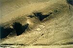
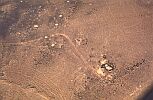
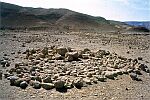
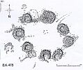
Another type of BAC settlement is called Plaza Site, which is characterised by several stone structures arranged in a circle around a central plaza. In a monographic study on "the Plaza Sites of Har Karkom" (E. Anati, 1987) about thirty such settlements were analysed in order to obtain a general view of them. They give rise to several queries. Such sites are known on both sides of the Arabah Valley - that is, both in the Israeli Negev and in Jordan - but nowhere else is such a large concentration known as at Har Karkom. In our area of research some of these sites may encompass as many as 26 structures and may have diameters of up to eighty meters. Such structures differ among themselves: some have a more round form and measure seven to eight meters in diameter. Some have a small courtyard by the side and appear to be living quarters. Other structures are stone platforms with small subterranean, bell-shaped silos in the vicinity, others appear just as heaps of stone that would require systematic digging for better analysis. Over half the plaza sites have nearby altar stones, orthostats with marks of fire, and other cult structures. Rock engravings are also common, appearing in small "sanctuaries" usually located forty to fifty meters outside the plaza site itself.
On the basis of flint tool typology, the majority of the plaza sites belong to an archaic phase of BAC (I and II), to the Chalcolithic, and to the beginning of the early Bronze Age. They seem to form a ring around Har Karkom along the main trails leading to the mountain, while maintaining a surprisingly constant distance from each other, averaging two to three kilometres. Five out of thirty of these settlements are double plaza sites; that is, two series of structures surrounding a circular plaza, one near the other, probably built in two separate phases. All the plaza sites, located on major trails with easy access, are on mild slopes and can be seen from a great distance. Additionally, they seem to have been set up on a system of intervisibility: from each plaza site one can see the nearest site in either direction.
A wide-ranging debate concerns the function of the plaza sites. After excavating and performing soundings in ten of these sites, the first hypothesis - that of funerary complexes - had to be dismissed. Not one of the excavated structures contained a burial. A second hypothesis suggested that the plaza sites were guard stations, but was discarded in the face of several facts: the plaza sites lacked defensive walls and were not strategically positioned on hilltops, consistent characteristics of guard sites of the same period. Near Beer Karkom a typical defensive site (BK407) has massive defence walls and towers.
Another hypothesis suggested that plaza sites may have been "boundaries" around a sacred mountain to demarcate the territory not to be surpassed by the populations living beyond. Such a restriction is reported by the Bible: "You must put barriers around the mountain and say, 'Take care not to go up the mountain or even to touch the edge of it.' Any man who touches the mountain must be put to death" (Exodus 19:12). According to this hypothesis, the early date of the plaza sites would indicate that bounding the sacred mountain was indeed an ancient tradition. Nevertheless a question arises. These sites, along trails to the mountain positioned at intervals all around it, may indeed have looked like boundaries when seen in later periods, and may have been interpreted as such, but originally they may have had different roles.
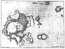
These plaza sites seem to have had special functions. They may well include living quarters, but their structures had different scopes. All of them are located along trails. They were topographically positioned differently from all the other BAC living sites. In one of the plaza sites, HK241, an area of less than two square meters yielded a concentration of several fan scrapers of excellent quality, apparently unused. This spot may have been the area of a flint craftsman, or a shop, or both. In another plaza site (HK152) a bell-shaped silo was dug into the earth, with a circular hole surrounded by stones at ground level and a base eighty centimetres below the surface. From the levels of the foundations, the hearths, and the stone doorsteps, it can be established that the BAC soil level was three to four centimetres higher than the present surface. At the bottom of the silo, a level of grey ash soil contained organic, carbonised materials. Also at this level was a grey rectangular earth block, likely the remains of a wooden box measuring about thirty by twenty centimetres, by twelve to fifteen, that probably contained a small quantity of highly-valued organic material. Since microscopic analysis did not provide any valuable hint to its contents, questions still remain about what was stored in this silo.
One gathers the impression that the plaza sites may have been commercial centres of some kind, but again new queries arise. It is not easy to imagine the functions of such "markets" around a mountain in the middle of the desert. The idea of a prehistoric Lourdes, with merchants offering ritual objects, incense, "holy water," drugs, or other objects of cult, though seductive, is far from proven.
In addition to the four types of BAC living sites we have described, remains of nomadic camping sites with floors of tents or of huts, and remains of living layers in caves and rock shelters are found from all periods, including the BAC. No doubt, in addition to the semi-sedentary and semi-nomadic populations, the area was also frequented by groups of nomads with temporary quarters. These different types of living arrangements indicate social and economic systems involving animal husbandry, agriculture, hunting and trade, with each element having a different importance at each described site. The hamlet sites were more or less permanent with an economy involving grain threshing. The courtyard sites were likely seasonal with a prevailingly patriarchal, pastoral economy. The row sites were primarily pastoral with a more rigid social structure of nuclear families. The plaza sites seem to have been involved in trade to a higher extent than the others.
Different tribes lived in the Har Karkom area during the BAC period, with varied living styles. The five types appear to have been more or less contemporary with each other, and all were used over a rather long span of time, from the Chalcolithic to the beginning of the middle Bronze Age. All the areas have been reoccupied several times, and secondary variations of structural character may reflect internal phases of the BAC period.
The various types of living sites, as we have seen, also reflected different manners of social organisation. The courtyard sites probably sheltered large clans. The row sites sheltered groups of nuclear families, while the hamlet sites may reflect human groups with more diversified internal relations. Sometimes the herds were the common property of the entire community, while in other situations each family owned its animals privately. Agriculture seems to have been a secondary activity for the peoples of all the living site types except the hamlet sites.
In addition to the remains of boulder terraces, evidence of regularly-spaced traces of holes, averaging a half to one meter in diameter, is found in the sloping areas by the sides of wadis. Soundings did not produce any findings from such holes except a flint herminet in one case. The fields of holes, generally connected to BAC sites, are likely to be all that remain of plantations of some kind of bushes. Such fields are different from fields covered by small heaps of stones known as tuleilat el 'anab, which are likely remnants of vineyard or orchards of fruit trees from the Nabatean period.
One tantalising question is whether among such a variety of settlement types, it is possible to recognise a type which may refer to the biblical stories of the children of Israel. Although it is tempting to draw a hypothesis, we prefer to delay any proposal of this character. All we can say at the moment is that if indeed the "children of Israel" were among those who stopped by the foot of the sacred mountain, they were certainly not the only ones to do so.
In accordance to the biblical accounts, Moses is said to have led the livestock of Jethro to the Mountain of God (Exodus 3:1). The biblical text may imply that according to tradition the site was already known as the Mountain of God before Moses arrived there. It is likely that this mountain, which the Bible describes as being located in the pastoral land of the Midianites, was a sacred high place for several desert tribes. The Bible says that Midianites, Amalekites, and Israelites were present nearby. The "mountain of the Amorite" was not far away, and thus the Amorites may also have been in the surroundings. The area of Mount Seir, also in the vicinity, was the land of the Edomites.
No doubt different populations were active in the area. Like in the biblical description of mount Sinai, the area of Har Karkom was a major cradle of desert people. Indeed there seems to be another concordance, between the biblical narration that describes a desert frequented by different tribes and the archaeological finds that indicate a variety of living models. The infrequent wells and water sources may have been meeting places as well as places of dispute between the different tribes. The defence of pasture areas was vital for survival, and this again may have provoked disputes in the midst of attempts at coexistence. This mosaic of life models among different populations is a view of how desert life may have unfolded during the BAC period.
Major queries persist. What drew all these people to a territory with scanty economic resources? Why so many villages and camping sites? Why cult sites? Why just in the area of Har Karkom and not elsewhere, and why was a cult high place from the Palaeolithic reused as a holy mountain in later periods?
The main development phase of Har Karkom as a tribal cult centre in the BAC period started in a moment of Mesopotamian cultural penetration into the area and concluded when the most significant external contact was Egypt. A major issue obviously remains that of the possible coincidence between the archaeological data and mytho-historical narration of the Bible. Another query as important is that of the discovery of this desert civilisation whose people did not build palaces, did not erect pyramids or ziggurats, did not display wealth, but did have an intense intellectual life in search of values and identity, and whose existence the official history of the Near East has practically ignored.
The problem of relations between the biblical narrative and archaeological finds comes to the surface again. The story emerging from the archaeological finds in this area brings to mind questions of the missing links of history. What was the role of these, so far anonymous, desert people in the creation and implementation of the moral and ethical messages which made the roots of western society? The ongoing investigations at Har Karkom may offer insights into the role of the periphery in the social and historical development of the Near East.
|
 Get the book for only 15. (you save 10.)