| |
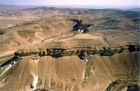
BEER KARKOM SITES 600-699
BK/601a
Coordinates: 122.4/975.8
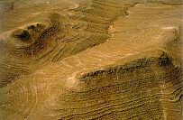
Description: Terraced-fields (BYZ) that have been employed recently with
traces of remaking. Remains of bivouac with recent windbreak
hut. The agricultural terracing has been attributed to the
denizens of site BK/602 (BYZ/Roman). The terraces along the
north border of the wadi Bereka are extended for a length of
about 350 m.
Finds: Remains of an utensils workshop; Pottery.
Periods MC: RBY.
Site typology:
BK601b
Coordinates: 122.5/975.5
Description: Agricultural terracing found at the bottom of the slope, similar to
site BK/601.
Finds: Pottery.
Periods MC: RBY.
Site typology:
BK/602
Coordinates: 123.1/975.6
Description: 1 oval stone structure and 1 almost rectangular courtyard on a
side wadi of Nahal Beroka. Traces of terracing nearby. Inside the
wadi there are remains of a village with 5 round living structures
(traces of Islamic remaking). Remains of a Bedouin encampment
are superimposed. This installation is at the foot of the caves and
at its base is a Bedouin cemetery.
Finds: Pottery.
Periods MC: RBY, ISL.
Site typology:
BK/602b
Coordinates: 122.9/975.6
Description: Remains of a nomadic encampment consisting of a rectangular
structure and rectangular huts, defined by alignments of stone.
Site typology:
BK/602 c
Coordinates: 123.2/975.5
Description: Group of small rock shelters. Bedouin stone-built storeroom.
Periods MC: ISL.
Site typology:
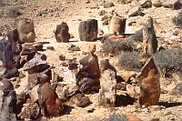
BK/603
Coordinates: 123.4/975.5
Description: 2 standing stones and several heaps of stones, on the northern
terrace at a sharp corner of Wadi Bereka.
Site typology:
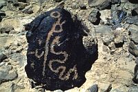
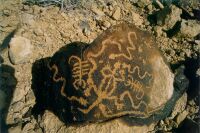
BK/603 b
Coordinates: 123.3/975.4
Description: In a little side valley at the Wadi Bereka there are numerous
caves and shelters. 1 of the shelters has closing walls of stone.
Some pools of water and numerous boulders rolled down into the
valley. 1 of the natually anthropomorphic-shaped boulders has
been hoisted up and is kept vertical by small stones supporting it.
Finds: Flint; Pottery.
Site typology:
BK/604a
Coordinates: 124.3/975.8
Description: 3 rectangular stone structures and remains of terraces on the
western side of a large lateral terrace of the wadi.
Finds: Pottery RBY.
Periods MC: RBY.
Site typology:
BK/604b
Coordinates: 124.4/975.9
Description: 5 rectangular stone structures, a large tumulus and several heaps
of stones, on the eastern end of a large terrace of the wadi which
has numerous remains of terracing.
Finds: Pottery RBY, HEL .
Periods MC: RBY, HEL.
Site typology:
BK/605
Coordinates: 124.2/976.5
Description: 2 circular stone structures (dwelling units), nearby are several
heaps of stones. On the terrace along the wadi is a large stone
with circular wall reutilized as a Bedouin grave.
Finds: Pottery IA, RBY.
Periods MC: IA, RBY.
Site typology:
BK/606
Coordinates: 123.6/976.5
Description: Remains of a settlement on a southern terrace of the wadi
showing at least 3 different phases of Description: The latest
seems to be a row of 3 rather small rectangular dwelling units. In
the center of the terrace there is a row of 5 larger structures
which are angular on 1 side and rounded on the other. 2 of them
seem to have been reused. Traces of at least 4 earlier structures
are found on the eastern terrace of this site. Further east there is
a circle of 9 standing stones and further on a group of 4 living
structures and a few heaps of stones nearby.
Periods MC: RBY.
BK/606b
Coordinates: 123.8/976.5
Description: A group of 4 oval stone structures along the foot of the hill. The
largest 1 is likely to have been an animal enclosure. Nearby a
small rectangular structure probably built during a different
period. On the edge of the wadi, some 20 m. from this group,
there is another rectangular structure. Nearby is a semicircle
composed by 12 standing stones. Several other heaps of stones
are spread all over the same area. About 25 m. east there is a low
tumulus surrounded by 9 standing stones. In the vicinity, other
groups of standing stones form small circles.
Periods MC: RBY.
Site typology:
BK/606c
Coordinates: 123.4/976.6
Description: 2 groups of piles of stones, probably a cemetery.
Site typology:
BK/607a
Coordinates: 123.4/976.8
Description: 5 circular stone structures in a row; to the east 5 smaller circular
stone structures arranged in a semicircle. There is a grinding
stone in the second dwelling unit from the south and all
structures are still standing. 5 strata of stone appear to have been
rebuilt.
Finds: Pottery Gaza, BYZ, ISL, Medieval; Flint UP.
Periods MC: RBY, ISL, UP.
Site typology:
BK/607b
Coordinates: 123.2/976.9
Description: 5 stone structures similar to those in BK/607a.
Finds: Pottery ISL
Periods MC: RBY, ISL.
Site typology:
BK/607c
Coordinates: 123.1/977.1
Description: From the slope of the mountain to the wadi, a series of 6 rec-
tangular stone structures likely to belong to 2 different periods; 2
of them are larger than the others and better preserved.
Finds: Pottery ISL.
Periods MC: RBY, ISL.
Site typology:
BK/607d
Coordinates: 123.3/976.7
Description: 2 tumuli on the edge of the mountain. A small rock shelter with
stone-built closing wall.
Site typology:
BK/608
Coordinates: 121.3/977.2
Description: Remains of stone bases of dwelling structures, 2 of them are
rectangular and the other circular. It is possible to clearly see 7
structures, and perhaps another 2. The largest structure,
measuring about 8 m. x 6 m. has in its corner 2 stones of natural
form, with anthropomorphic faces. 1 of them has the mouth and
nose retouched by man. In this structure the stone at the entrance
has the "zoomorphic" face on 1 side and on the other, a face
naturally formed but, perhaps, retouched by man. Opposite the
entrance there is a large black stone of natural cubic form. In
what appears to be the entrance of the structure, there are 2
striking stones. 1 has a probable bestial or monstrous face and
the other has an anthropomorphic face. On the left side of the
entrance there is a small stone barrow with 4 pillars which are
now fallen. The rectangular structure at the south border of the
installation is probably Islamic. The others are older. 1 of the
structures is eight-shaped. On the other side of the wadi, 60 m.
further North, a funerary area with standing stones and tumuli.
Finds: Pottery (ISL); Flint (BAC or NEO?).
Periods MC: NEO, BAC, ISL.
Site typology:
BK/608b
Coordinates: 121.3/977.4
Description: A round structure, a tumulus and remains of a small geoglyph: a
rounded shape with a tail. The circle has a diameter of ca. 1.30
m. and the tail is 1.80 m. long.
Site typology:
BK/609
Coordinates: 121.0/977.2
Description: A circular stone structure east of the wadi.
Site typology:
BK/610
Coordinates: 124.0/975.3
Description: A circular stone structure.
Site typology:
BK/610b
Coordinates: 124,170 / 975,20
Description: Two rock shelters.
Finds: Flints.
Periods MC: BAC.
Site typology: Rock shelter.
BK/611
Coordinates: 124.5/975.7
Description: At least 6 hut floors on the top of the hill.
Site typology:
BK/612
Coordinates: 124.6/975.7
Description: A rectangular stone structure.
Site typology:
BK/613
Coordinates: 125.0/975.5
Description: Remains of 5 hut floors, Palaeolithic in type, on a top of a low
hill. In the surroundings, there are several stone structures: a
temporary encampment and many piles of stones, probably
remains of an ancient cemetery.
Finds: Scarce, atypical Middle Palaeolithic flints. A Mousterian point.
Periods MC: MP.
Site typology: Campsite, encampment, piles of stones.
Bibliography
BK/614
Coordinates: 125.4/975.7
Description: Stone structures on the top of a hill: one tumulus, several piles of
stones and 4 hut basements, probably a temporary encampment.
Two elongated areas cleared of stones, with piles of stones in the
corners and on the border. One, aligned at 190°, is 15.9 m long
and 1.90-1.20 m wide; the other, aligned at 150°, is 17 m long
and 2.0-1.6 m wide: at the top and at the bottom there are two
other elongated cleared areas, 3 m long. The ensemble may be a
geoglyph.
Finds: No material culture found.
Periods MC:
Site typology: Encampment, geoglyph?, piles of stones, tumulus.
Bibliography:
BK/615
Coordinates: 125.5/975.6
Description: Temporary encampment with at least 10 hut basements.
Finds: No material culture found
Site typology: Encampment
Bibliography:
BK/616
Coordinates: 125.6/975.7
Description: Temporary encampment with at least 6 hut basements.
Finds: No material culture found
Site typology: Encampment
Bibliography:
BK/616b-c
Coordinates: 125.6/975.8
Description: Remains of 4 hut floors, Palaeolithic in type. One is surrounded
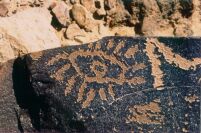
by stones. Some heaps of stones around. One small, black rock
with engravings 100 m further North (BK/616 c)
Finds: Atypical MP flints. A hammerstone.
Periods MC: MP.
Rock Art: One engraved rock
Periods RA: ?
Site typology: Campsite, rock art.
Bibliography:
BK/616d
Coordinates: 125.4/976.1
Description: Dwelling site at a wadi junction on both side terraces: 4 round,
well preserved stone structures in a row and other minor
structures on one side; two round stone structures and two tumuli
on the other side.
Finds: Byzantine pottery.
Periods MC: RBY.
Site typology: Row.
Bibliography:
BK/617
Coordinates: 125.8/975.8
Description: Evidence of surface cleaning, remain of an ancient temporary
encampment. Heaps of stones.
Finds: No material culture found.
Periods MC:
Rock Art: One engraved rock.
Periods RA: AR VII.
Site typology: Encampment, heaps of stones, rock art.
Bibliography:
BK/617b
Coordinates: 125.8/976.1
Description: Remains of two hut floors, Palaeolithic in type, 100 m North of
BK/617, on a lower terrace. Two heaps of stones further West. A
natural flint hill overlooks the site.
Finds: No material culture found.
Periods MC:
Site typology: Campsite, heaps of stones.
Bibliography:
BK/618
Coordinates: 126.2/975.7
Description: A group of 8 hut floors arranged roughly in a circle on a hilltop.
3 other hut floors are north of the circle, 1 to its west. At least
two different phases can be recognized in the utilization of this
site.
Site typology:
BK/619a
Coordinates: 126.5/975.5
Description: 3 hut floors, on a flat area near a hilltop.
Site typology:
BK/619b
Coordinates: 126.5/975.4
Description: 80 m. south of site BK/619. 1 stone structure and 2 heaps of
stones, on the southern side of a small wadi.
Site typology:
BK/620
Coordinates: 126.1/976.0
Description: Remains of walls belonging to at least 2 stone structures.
Site typology:
BK/621
Coordinates: 126.6/976.3
Description: A small hamlet consisting of 4 main structures, the central one is
composed of an oval living structure with a courtyard in front of
it. On each side there is 1 rectangular structure. The 4th structure
is smaller than the others and seems to be a storing place. West
of the above mentioned structure, there are remains of a fifth
structure.
Site typology:
BK/622
Coordinates: 125.3/976.5
Description: Remains of a rectangular structure on a terrace, at the confluence
between Nahal Karkom and a lateral wadi. Other groups of
aligned stones seem to indicate the presence of remains of
additional stone structures. 1 of them could be an animal
enclosure. 1 tumulus.
Site typology:
BK/623a
Coordinates: 124.9/976.4
Description: 2 groups of standing stones, on the southern terrace of the wadi,
indicating that this site was used at least during 2 different
periods. 1 group counts 3 large oval structures and the other 5
smaller angulated structures.
Site typology:
BK/623b
Coordinates: 125.0/976.5
Description: 2 large dwelling units, 1 of which is angulated on 1 side, the
other is oval. Several heaps of stones in the vicinity.
Site typology:
BK/624
Coordinates: 125.1/976.7
Description: 10 small circular piles of stones along the bank of the wadi. 2
larger dwelling units are 50 m. further east. 1 of them is almost
perfectly round, the other larger 1 is angulated on 1 side and
rounded on the other.
Finds: Pottery RBY, ISL.
Periods MC: RBY, ISL.
Site typology:
BK/625
Coordinates: 124.6/976.7
Description: 4 circular piles of stones along the edge of the wadi. They are
probably tumuli.
Site typology:
BK/626
Coordinates: 124.2/976.8
Description: 8 circular stone dwelling units along the wadi. 2 of them are
larger than the others, with 3 rooms and a courtyard, angulated
on 1 side and rounded on the others; to its west side there is a
well built tumulus. 5 of them are oval and another one
rectangular.
Periods MC: RBY.
Site typology:
BK/627
Coordinates: 126.3/976.6
Description: 9 hut floors arranged in an ellipse on the top of a hill.
Site typology:
BK/628
Coordinates: 126.8/976.4
Description: 6 standing stones arranged in a circle and several piles of stones
around them. Remains of 5 dwelling units made of stone.
Site typology:
BK/629
Coordinates: 126.3/976.0
Description: 6-7 aligned hut floors on the top of a hill.
Site typology:
BK/630
Coordinates: 126.6/976.1
Description: 10 aligned hut floors.
Site typology:
BK/631
Coordinates: 126.7/976.1
Description: At least 9 aligned hut floors.
Site typology:
BK/632
Coordinates: 127.0/976.7
Description: 6 aligned rectangular stone structures, 3 more structures further
south.
Periods MC: RBY.
Site typology:
BK/633
Coordinates: 127.2/976.6
Description: 9 hut floors scattered south of the path, 2 stone-built living
structures and a large stone circle.
Site typology:
BK/634
Coordinates: 127.3/976.6
Description: A stone circle.
Site typology:
BK/635
Coordinates: 127.5/976.9
Description: On the top of a hill, baements of huts in an extensive scatter.
This site seems to have been utilized during different periods.
Site typology:
BK/636
Coordinates: 128.2/977.3
Description: A cluster of 9-10 hut floors east of the path and at least 3 hut
floors to the west.
Site typology:
BK/637
Coordinates: 128.8/977.4
Description: A group of 5 hut floors.
Site typology:
BK/638
Coordinates: 128.9/977.1
Description: 5 hut floors of Palaeolithic type in a row.
Site typology:
BK/639
Coordinates: 129.8/977.2
Description: 3 circular stone structures and a tumulus to their north; a part of
a rectangular stone structure on the bank of the wadi. 1 hut floor.
Periods MC: RBY.
Site typology:
BK/640a-b
Coordinates: 129.7/976.7
Description: 3 large stone structures and remains of 3 smaller ones. They
form a large circle. West of this site, in a small lateral wadi,
remains of 7 aligned rectangular structures. On the other side of
the wadi, remains of 2 large enclosures. (BK/640b).
Periods MC: RBY.
Site typology:
BK/641
Coordinates: 128.9/975.9
Description: 4 circular stone structures and other piles of stones on the
northern bank of Wadi Karkom. On the opposite side of the
wadi, near the confluence with a lateral wadi, a small kharaba,
where water may have been collected.
Periods MC: RBY.
Site typology:
BK/642
Coordinates: 128.6/976.8
Description: A tumulus and a stone circle surrounding it; west, another
tumulus with its surrounding circle partly destroyed.
Site typology:
BK/643
Coordinates: 128.5/976.7
Description: At least 10 hut floors on the top of the hill; 3 small caves below
the ridge show signs of having been used by man.
Site typology:.
BK/644
Coordinates: 128.2/976.4
Description: 4 aligned hut floors and several pillars of standing stones.
Site typology:
BK/645
Coordinates: 129.4/975.5
Description: Several hut floors along the path.
Site typology:
BK/646
Coordinates: 129.0/975.5
Description: A large tumulus on the top of the hill surrounded by a circle that
is partly natural and partly artificial.
Site typology:
BK/647
Coordinates: 128.8/975.4
Description: A strip of over 15 hut floors of Palaeolithic type.
Periods MC: PAL.
Site typology:
BK/648
Coordinates: 127.6/975.6
Description: 3 hut floors in a row.
Site typology:
BK/649
Coordinates: 126.8/975.4
Description: At least 4 hut floors by an ancient path on the top of the hill.
Site typology:
BK/650
Coordinates: 126.9/975.2
Description: 6 standing stones arranged roughly in a row, 2 stone structures
and the remains of a third by the wadi.
Site typology:
BK/651
Coordinates: 129.8/974.9
Description: Basements of huts and piles of stones on top of the hill.
Site typology:
BK/652
Coordinates: 129.4/974.6
Description: 3 and possibly more hut floors on top of the hill.
Site typology:
BK/653
Coordinates: 129.3/974.4
Description: 12 piles of stones forming a circle; 1 inside the circle and 3
outside.
Site typology:
BK/654
Coordinates: 129.5/974.0
Description: Several piles of stones arranged roughly in an ellipse.
Site typology:
BK/655
Coordinates: 128.7/973.9
Description: A cluster of 8 hut floors, 3 of which are considerably larger than
the others; several piles of stones.
Site typology:
BK/656
Coordinates: 129.2/973.7
Description: 11 hut floors roughly forming a circle.
Site typology:
BK/657
Coordinates: 129.2/973.3
Description: 5 hut floors, a tumulus and 5 standing stones in a row.
Site typology:
BK/658
Coordinates: 128.9/973.0
Description: Basements of huts, 5 are aligned.
Site typology:
BK/659
Coordinates: 127.6/973.4
Description: Traces of a Bedouin encampment; piles of stones.
Periods MC: ISL .
Site typology:
BK/660
Coordinates: 126.4/973.8
Description: 7-8 hut floors of Palaeolithic type on the top of the mountain. 66
piles of stones in a circle. Most likely the 2 types of remains
correspond to 2 different cultural episodes.
Site typology:
BK/661
Coordinates: 126.7/973.7
Description: Remains of an encampment, probably Bedouin, in a small valley.
Periods MC: ISL.
Site typology:
BK/662
Coordinates: 128.6/972.8
Description: Remains of agricultural terracing.
Periods MC: RBY.
Site typology:
BK/663
Coordinates: 128.8/972.4
Description: Remains of 2 animal enclosures, 1 oval and 1 rectangular;
remains of stone walls and a canal to collect water from the
wadi; agricultural terracing; remains of at least 5 living
structures .
Periods MC: RBY, ISL.
Site typology:
BK/664
Coordinates: 129.2/972.3
Description: 10-11 hut floors in a circle. At least 4 contiguous hut floors
near the center of the circle.
Site typology:
BK/665
Coordinates: 128.5/972.0
Description: Remains of agricultural terracing.
Periods MC: RBY.
Site typology:
BK/666
Coordinates: 128.1/972.1
Description: 7 small oblong stone structures roughly in a semicircle. Several
piles of stones, probably tombs. Remains of 4 scattered living
structures, each one built during a different period.
Site typology:
BK/667
Coordinates: 128.0/972.0
Description: A spiral-shaped structure and 4 rectangular structures arranged
in a row.
Site typology:
BK/668
Coordinates: 127.1/972.7
Description: 10-11 piles of stones in a circle.
Site typology:
Bibliography: EA87, pp. 21 & 209.
BK/669
Coordinates: 127.5/977.2
Description: 20 hut floors, 8 of which are arranged in a circle.
Site typology:
BK/670
Coordinates: 127.4/977.5
Description: Remains of agricultural terracing.
Site typology:
BK/671
Coordinates: 127.1/977.7
Description: A large stone circle and south, 3 standing stones.
Site typology:
BK/672
Coordinates: 126.2/976.7
Description: 5 circular stone structures in a row along the wadi; traces of
walls and a circular stone structure further north. A wall in front
of a small rock shelter and remains of terracing.
Site typology:
BK/673
Coordinates: 126.4/977.4
Description: 2 rock shelters on both sides of the wadi with paths leading to
them.
Site typology:
BK/674
Coordinates: 128.8/974.6
Description: A group of 6 stone structures form a semicircle. 3 of them seem
to be chambered, the others are small piles of stones.
Site typology:
Bibliography: EA87, p. 211.
BK/675
Coordinates: 128.6/974.7
Description: 4 hut floors.
Site typology:
BK/676
Coordinates: 127.6/975.3
Description: A group of small rock shelters, in a secluded area, just below the
top of a mountain difficult to access. A trail leads to them indi-
cating utilization.
Site typology:
Bibliography: EA87, p. 211.
BK/677
Coordinates: 126.0/974.8
Description: On the top of a mountain, a rectangular stone enclosure built
against a cleft.
Site typology:
BK/678
Coordinates: 126.0/974.3
Description: 8 heaps of stones forming an oval. The area inside the circle is
cleared of stones.
Site typology:
Bibliography: EA87, p. 211.
BK/679
Coordinates: 127.8/974.3
Description: A stone circle at the confluence of 2 wadis.
Site typology:
BK/680
Coordinates: 123.8/976.9
Description: On the northeast side of the wadi, there is a group of courtyard
structures and stone dwelling units.
Periods MC: BAC.
Site typology:
BK/681 a
Coordinates: 123.3/977.4
Description: In the bed of a small wadi are remains of agricultural terracing
that presumably are related to the installations (RBY) of site
BK/607.
Periods MC: RBY.
Site typology:
BK/681 b
Coordinates: 123.3/977.6
Description: In the bed of a small wadi are the remains of agricultural
terracing that presumably are related to the installations of site
BK/607.
Periods MC: RBY.
Site typology:
BK/682
Coordinates: 123.7/977.6
Description: Agricultural terracing.
Site typology:
BK/683
Coordinates: 123.9/977.8
Description: Large round stone structure with small rooms along the
perimeter (probably BAC). 100 m. south, vestiges of terraced
fields in the bed of the wadi (RBY).
Periods MC: RBY, BAC.
Site typology:
BK/684
Coordinates: 123.8/978.1
Description: Remains of agricultural terracing in the wadi.
Periods MC: RBY.
Site typology:
BK/685
Coordinates: 123.6/978.4
Description: Remains of agricultural terracing.
Periods MC: RBY.
Site typology:
BK/686
Coordinates: 123.8/978.5
Description: Remains of a nomadic encampment at the confluence of the 2
wadis.
Periods MC: ISL.
Site typology:
BK/687
Coordinates: 123.4/979.2
Description: Remains of agricultural terracing and heaps of stones, probably
tumuli.
Periods MC: ISL?.
Site typology:
BK/688
Coordinates: 123.5/979.4
Description: Remains of agricultural terracing.
Periods MC: RBY.
Site typology:
BK/689 a-b
Coordinates: 123.7/979.8
Description: On the east side of the wadi, remains of agricultural terracing in
the bed of a small lateral wadi. 40 m. west of the terraced-fields,
a group of stone barrows, 5 of them well preserved and several
destroyed. On the largest tumulus there is an anthropomorphic
stone with artifically-shaped eyes.
Finds: Pottery BYZ; Flint MP
Periods MC: MP, BAC?, RBY.
Site typology:
BK/690a
Coordinates: 124.2/979.8
Description: Remains of agricultural terracing and a heap of stone likely to be
a burial.
Finds: Pottery BYZ.
Periods MC: RBY.
690b
Coordinates: 124.2/979.9
Description: Rock shelter with some stone walls.
Finds: Upper Paeleolithic flints, BYZ and ISL pottery.
Periods MC: UP, RBY, ISL.
BK/691
Coordinates: 124.3/979.8
Description: Remains of a nomadic encampment and stone enclosure.
Periods MC: ISL.
Site typology:
BK/692 abc
Coordinates: 124.6/979.6
Description: Along the bed of the wadi exist remains of agricultural terracing
that are recognizable at intervals for about 300 m.
Site typology:
BK/693
Coordinates: 124.9/979.3
Description: Remains of agricultural terracing.
Periods MC: RBY.
Site typology:
BK/694
Coordinates: 124.8/978.7
Description: On the tableland remains of 8 hut floors (PAL).
Periods MC: PAL.
Site typology:
BK/695
Coordinates: 124.6/978.6
Description: Remains of agricultural terracing.
Site typology:
BK/696
Coordinates: 124.3/978.7
Description: Remains of agricultural terracing.
Site typology:
BK/697
Coordinates: 124.7/978.4
Description: Remains of agricultural terracing.
Site typology:
BK/698
Coordinates: 124.8/978.3
Description: In the wadi, remains of an encampment and agricultural
terracing.
Periods MC: BAC, RBY.
BK/699
Coordinates: 124.9/978.2
Description: Remains of agricultural terracing.
|
 Get the book for only 15. (you save 10.)