| |
TOPOGRAPHY AND EXEGESIS
Reading through the biblical account of the Exodus one finds numerous indications concerning the compilers' conception of Mount Sinai's topography. Having done archaeological work in the Negev and Sinai for over forty years and being thus familiar with the landscape and geography of this area, it seems to us that the characteristics of many biblical descriptions concerning the sites mentioned and their topography are real and may be recognisable. In our view, those who described them were well acquainted with regional geographical details, or at least had access to reliable information. We wish to emphasise that we do not share the idea of those who claim that the identification of the biblical stations is impossible, or even that they have no connection with real territory. To our mind the itinerary of the Exodus as described in the books of Exodus and Numbers, from the land of Goshen to Mount Sinai, to the fields of Moab and Jericho, referred to real sites that were well known by travellers at the time of the compilation, therefore the route may be reconstructed in our own time.
With the progress of exploration and research, a rough sketch of this itinerary has been filled in and enhanced by archaeological finds and by parallels with the topography and the landscape. Recently we were able to propose an identification of the two biblical stations Marah and Elim respectively with El Murra and with the surroundings of Abu Awgeila in the northern Sinai. Also Beer Karkom, seven kilometres to the north of Har Karkom, may well be the real biblical site of Rephidim, the last station before reaching Mount Sinai. The biblical descriptions are realistic and in our view the topography corresponds. If, as we trust, sufficient evidence exists for the identification of these three sites, the area in which Mount Sinai may be located is thus circumscribed. This aspect of the real topography of Exodus is treated in detail in the volume Esodo tra Mito e Storia (1997).
Beyond what has been written already and the new evidence acquired on these three sites, a fundamental question has to be asked: after a long sojourn at the foot of Mount Sinai, the biblical itinerary continued in a territory that reflected the compilers' real conception of the location of Mount Sinai. Was this near or far away from the borders of the "Promised Land?" Some scholars maintain that it crossed the entire Sinai Peninsula from the south, where the Byzantine Monastery of Saint Catherine is located, to Ein-Kudeirat at the foot of the Negev highlands. The analysis of the names mentioned in Numbers 10 through 13, however, seems to indicate another geographical area.
The described itinerary led the Israelites to "the way of the mountain of the Amorite" (Deuteronomy 1:7, 1:19), referring to a specific real tribal territory. Various passages of the Bible locate the Amorite tribes at the time of Exodus not far from the Dead Sea and the Arabah Valley. The Paran Desert near Hazeroth is described as the site from which the "explorers" reached Hebron through the Desert of Zin (Numbers 13:1). This latter desert in the biblical narrative includes what is today called Nahal Zin, from the Arabah Valley to Sde-Boker north of Har Karkom. In later times it was crossed by an important caravan route from the Arabah Valley towards Arad and Hebron through which spices and perfumes were brought from Arabia to Syro-Palestine. The name of Bene-Jaakan refers to a Horite tribe (Numbers 33:32), and the Horites, according to biblical description, were at the time of the Exodus located on the east side of the Arabah Valley, again not far from the Dead Sea. The sites of Jotbathah and Ebronah are in the Arabah Valley (Numbers 33:34); Jotbathah in particular is described by the biblical texts in an unequivocal manner in the same real location as the present-day Yotvata. Ezion-geber, near the present-day Eilat, was a harbour on the Red Sea and its real location as such is defined in the Bible (Numbers 33:36). All these descriptions have a geographical logic that outlines a general real setting of a region to the west of the Arabah Valley, and east of the Central Negev highlands.
Biblical texts have a consistent topographic concept of the geography of Mount Sinai and locate this holy mountain between the Deserts of Zin and Paran, between the land of Amalek and the land of Midian, between Elim and the "way of the mountain of the Amorite." Several passages of the Bible indicate the view of the compilers about the real location of the deserts and the territories mentioned above. The lands of Amalek and Midian, and of the Amorites and the Horites are clearly defined according to the geographical conception of the biblical compilation. The biblical texts localised Mount Sinai even more precisely: "Moses kept the flock of his father-in-law Jethro, priest of Midian. He led the flock across the wilderness and came to Horeb, the mountain of God" (Exodus 3:1). In the story of Moses in Midian, the mountain of God is located in the pastoral land of the Midianites, beyond the desert, presumably the Paran Desert. The Midianite tribes, according to the biblical books Exodus and Numbers, appear to be located by the sides of the southern Arabah Valley. When Moses went back to Egypt from Midian on the road between Jethro's land and Egypt, his brother Aaron met him at the mountain of God (Exodus 4:27). According to the biblical narration, Moses' Midianite family accompanied him all the way to Mount Sinai where his brother Aaron came from Egypt to meet him. Following the customs of the desert, this would seem to indicate that in the view of the compiler, Mount Sinai, where his family left him and his brother came to meet him, is located on the border of the land of Midian towards Egypt. It can be seen on a map that Har Karkom is located on the line that leads from Midian to Egypt.
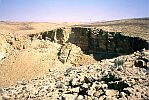
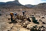
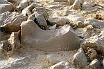
The site of Rephidim is described by the Bible as the last station where the children of Israel stopped before reaching Mount Sinai. It was near enough to Mount Sinai for them to go there daily to collect water. This indicates the real geographical viewpoint of the narrative's compilers. Rephidim is described in the book of Exodus as causing discussion and dispute (according to the Hebrew text, massa umeriva), probably between the two neighbouring tribes. The place in dispute was a real water source on the border between Amalekite and Midianite territories, and according to the text, both tribes appeared at Rephidim to claim ownership of the well in two different ways, the Amalekites by aggression and the Midianites by alliance. The Bible describes the location of the Midianites at the sides of the Arabah Valley and the Amalekites on the central Negev highlands stretching to Kadesh-barnea. The well of Beer Karkom, seven kilometres to the north of Har Karkom, which has remains of large camping sites from the BAC period, corresponds to the real topographical description the Bible gives of Rephidim.
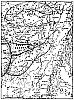
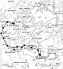
Other biblical descriptions as well show the consistently topographical view of territory in biblical texts. At the beginning of Deuteronomy it is written, "It is eleven days journey from Horeb, by the way of mount Seir, to Kadesh-barnea" (Deuteronomy 1:2). The context of this passage is not clear. According to most biblical scholars it does not refer to the itinerary of Exodus. In our view it simply describes one of the pilgrim's trails leading from Kadesh-barnea to the real Mount Sinai. For many scholars, including those who do not accept the identification of Har Karkom, Kadesh-barnea should be located at Ein-Kudeirat or in the nearby well of Ein-Kadis. Mount Seir (meaning "hairy") is likely to be Jebel Arif el-Naqe. To the north and east of this mountain is a valley with water and pastoral lands and the wells of Bir Main and Bir el-Beidha. It is a truly "hairy" mountain in the sense that it has bushy vegetation at its base. Today this area is an important Bedouin centre where several tribes are located almost permanently. The valleys surrounding Jebel Arif el-Naqe may well fit the real topographic and environmental characteristics of the biblical land of Seir, homeland of the Edomites. An ancient trail links Har Karkom and Ein-Kudeirat by way of Jebel Arif el-Naqe. Ten groups of wells, at intervals of seven to fifteen kilometres, sustain travellers. If Har Karkom is the real Mount Sinai, for a group of people walking it is exactly eleven days from Horeb by Mount Seir to Kadesh-barnea.
Before the domestication of the camel, a family group with women, children, and the elderly could barely have travelled fifteen kilometers a day, and every evening they would need water. From Har Karkom to Ein Kudeirat (Kadesh-barnea) by the way of Jebel Arif el-Naqe (Mount Seir) water sources are available at intervals of no more than fifteen kilometers as shown below:
| 1. Har Karkom to Beer Karkom
| 7 km |
| 2. Beer Karkom to Thumilat Bereka
| 15 km |
| 3. Thumilat Bereka to Ein Mughara
| 13 km |
| 4. Ein Mughara to Bir Main
| 7 km |
| 5. Bir Main to Bir el-Beida
| 9 km |
| 6. Bir el-Beida to Riyash
| 14 km |
| 7. Riyash to Thumilat el-Aguz
| 13 km |
| 8. Thumilat el-Aguz to Tabghat ez-Zafra
| 15 km |
| 9. Tabghat ez-Zafra to Bir es-Saida
| 11 km |
| 10. Bir es-Saida to El Kuseime
| 12 km |
| 11. El Kuseime to Ein Kudeirat
| 8 km |
| Total
| 124 km |
With camels, four to five days are required; with a jeep the distance can be covered in one day. For a group of people walking, eleven days are needed to go from Har Karkom to Ein Kudeirat by way of Jebel Arif el-Naqe (BSCP 24, p.10 1988).
According to the topographical view of the compilers, several tribes were in the vicinity of the real Mount Sinai, such as the Amorites and the Horites. It appears that the text of the Pentateuch includes geographical passages with fairly precise real indications. The Bible describes deserts and tribal zones around Mount Sinai. One of the determining elements seems to be that the real Mount Sinai, according to the narrative is located in Midianite territory near the border of Midian and Amalek (Exodus 17:9-16). As already mentioned, the Bible locates the Amalekites on the Negev highlands and in the area of Kadesh-barnea, and the Midianites by the sides of the Arabah Valley. Mount Sinai, according to the biblical narrative, is located between these two regions, the Arabah Valley and Negev highlands, in the area of Har Karkom. Apparently, the compilers knew where the Mountain of God was, and they did not doubt that this was also familiar territory to the readers of their texts. A thorough analysis of all the topographical clues provided by the Bible on Mount Sinai suggest it is located in the area of Har Karkom even without taking into consideration the archaeological discoveries at Har Karkom.
|
 Get the book for only 15. (you save 10.)