| |
ENIGMATIC DISCOVERIES
Desert areas open to exploration are troves of unpredictable surprises. After passing through an area over and over again, each time researching and believing all the available information has been collected, new details still remain to be discovered: alignments, heaps of stones, geoglyphs, remains of hut floors, traces of camps may reveal unexpected hints each time they are revisited. After 20 years of fieldwork, new observations provide new findings of material culture. Sometimes such finds cannot be promptly deciphered. They raise questions which may remain open. In this chapter we shall present a few examples.
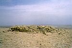
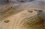
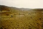
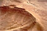
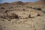
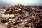
A group of four stone platforms built on top of a peak about three kilometres south of Har Karkom (site HK 301) prompts discussion. Well-preserved and still standing a meter above the soil, these monumental structures are finely built with unworked stones of intermediate dimensions. Similar platforms are known from the archaeological excavations at Megiddo, Arad, and other sites. At site HK 301, the largest of the platforms is ten meters in diameter, another is slightly smaller, and the smallest two are about eight meters in diameter. Two of these platforms are surrounded by circles of smaller stones. The few lithic findings related to this site are all from the BAC period dating back to the third millennium BC. Since some members of the expedition argued that they might be tombs, in 1998 one of these platforms was excavated down to the bedrock by a team co-ordinated by Valerio Manfredi. No burial or other remains were found. The filling was just made of stones. The platforms are flat on top and the stones appear to have been cemented by a powerful fire. Professor Noam Lahav, from the Seagram Center for Soil and Water Sciences in Jerusalem, determined that a heat intense enough to melt the stone in this manner could not have originated as an open-air fire of wood or animal excrement. It is not unlikely that the BAC peoples had access to a different fuel for combustion. Since bitumen, sulphur, and saltpetre are found naturally in the area or at short distances, one should not exclude the possibility that some Bronze Age shaman or medicine man knew the particular qualities of these materials.
Several hypotheses have developed on the possible function of the site of the "Burned Platforms," located on a peak which can be reached by a long, hard climb.
It was proposed that they may have been bases for funerary pyres, but a detailed examination of all fissures and holes of these monuments did not yield a single piece of bone. In fact, the only bone fragment found at the site came from a small heap of stones covered by evidence of burning, possibly a fireplace, at a distance of about fifteen meters from the nearest platform. The find, showing an advanced degree of fossilisation, was a fragment of a long bone from a large ruminant, probably an ox. If not funerary in purpose, what could these platforms be? Some colleagues have attempted a reference to the dramatic biblical texts of Exodus 19:18: "Mount Sinai smoked in every part because the Lord descended upon it in fire: and the smoke of it ascended like the smoke of a furnace, and the whole mountain quaked greatly" and again, "The sight of the glory of the Lord was like a devouring fire on the top of the mountain in the eyes of the children of Israel" (Exodus 24:17). But this site is not Har Karkom itself; it is a peak separated from Har Karkom by a saddle of hills. Traces of fire are also found on Har Karkom. It seems that the fires had a very important role, especially in sites where rock art is concentrated, though on the plateau of Har Karkom so far, no similar stone platforms showing evidence of such strong conflagrations have been found. Since we know from other investigations that sacred fires were not unknown in the ancient Near East; the four "Burned Platforms" may have been altars, pyres or some other ritual spaces for which fires were central; in any case, fire and smoke from this peak would have been visible from far away.
The peak of the "Burned Platforms" is a sort of protrusion of Har Karkom which dominates the entire Paran Desert from Paran to Kuntilla. From the site of the platforms the view of the horizon is nearly 360 degrees. If the present-day Paran Desert had the same name at the time of the Bible, this mountain is the most likely to have been called Mount Paran because it is the only one which truly has an overview of the desert.
The Bible indicates the presence of three theophanic mountains in the same area: "The Lord came from Sinai and rose up from Seir to them;. he shone forth from Mount Paran" (Deuteronomy 33:2). The area the text refers to, which lies not far from Kadesh-barnea in the north of the peninsula, must have been well known at the time the text was written. As in previous instances, we are assuming that the names refer to existing sites, not just to "celestial" sites as some biblical scholars tend to believe. However, two major questions arise. One concerns the possible connection between a site found in the landscape with the name mentioned in the biblical text. The second question concerns the function that such sites had when they were in use, which is frequently not directly revealed by either the archaeological finds or the biblical descriptions.
Both the archaeological sites and the biblical descriptions illustrate a serious concern among the desert people for a ritual choreography. Spectacular blazes on this mountain may have been astonishing, but what kind of performances took place around such fires? The question unfortunately remains unanswered.
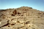
Among recent discoveries, an Iron Age settlement found at the foot of the mountain is worth mentioning for its role as the first settlement to be established after a millennium long abandonment. Though 1200 sites in the area of concession are known, after the exuberant BAC period a hiatus covers the second phase of the middle Bronze Age, the entire late Bronze Age, and the beginning of the Iron Age. After this extended lapse of time, the first traces of a renewed human presence were found at site HK 173, with pottery of the ninth century BC. Near Beer Karkom are eight Iron Age sites, but HK 173 is the first discovered which may be recorded as a cluster of living quarters, a settlement. In the small village, eight structures with stone foundations and a modest-sized shrine have been recorded. In this shrine a standing stone is in situ, in front of which is a stone with a large cup-mark intentionally propped on smaller stones. Pottery from this site is similar to that found in the central Negev in several excavations by Rudolph Cohen. The structures at the Har Karkom site appear to have been built at the same time, and they show no traces of repair, so it is unlikely that they were in use for more than a single season. There is however evidence of reuse and repair at two of the stone structures at a later period; as we learn from findings of Roman pottery.
Another peculiar coincidence occurs between the biblical description of Mount Sinai and the archaeological sequence at Har Karkom, which once again seems to correspond to biblical accounts. According to the Bible, it was centuries after Moses left Mount Sinai with the children of Israel that the first visitor returned to the mountain. This was the prophet Elijah: "He arose, and did eat and drink, and went in the strength of that meal forty days and forty nights to Horeb the mountain of God. And he came there to a cave and lodged there" (I Kings 19:9). The archaeological survey at Har Karkom indicates a long interval between the end of the BAC period and the first Iron Age settlement, which goes back to the ninth century BC (site HK 173). Elijah lived during the reign of King Ahab (876-854 BC). All we can do is note the strange coincidence; currently we have found no Iron Age remains in any of the explored caves at Har Karkom.
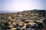
The largest settlement found so far in the area has been localised by the archaeological survey to site BK 480. This site, consisting of 126 living structures, was previously noted from aerial photographs. If one accepts the standard evaluation of an average of 5 people per living structure, this small town would have sheltered over 600 people. Its survey revealed a quantity of Hellenistic pottery dating to the late fourth century BC, the period of Alexander the Great, an era of explorations, conquests, and military expeditions. The site was well-planned; all the habitations were apparently built simultaneously and were organised in rows following elongated hills with wadis to each side. Around the settlement, small rectangular structures appear to be guard posts. The settlement had a brief existence and was certainly planned by a central regime. This could well be the relic of a military outpost, but the question remains open: who were the colonisers who planned and built it and departed soon thereafter?
Site BK480 is the largest, but eight other Hellenistic sites in the area of Beer Karkom have been recorded dating back between 330 BC and the beginning of the Roman age, which, according to archaeological conventions of the Palestinian area, starts in the year 37 BC. The Roman and Byzantine periods reveal an intensive colonisation of numerous living sites, and agricultural terracing. Between the area of Har Karkom and that of Beer Karkom, over 200 archaeological sites of the Roman-Byzantine period have been recorded.
The entire region was then abandoned in the early centuries of the Islamic age. According to pottery and other finds, the last villages survived until shortly after 1000 AD, and thereafter the area reverted to wilderness. Populations continued to move through the area; remains of as many as 148 nomadic camping sites have Islamic findings belonging to the second millennium AD.
Another enigmatic find concerns a small Hellenistic sanctuary on the top of a mountain two kilometres north-west of Har Karkom (site HK 221B), which was excavated and published by a team co-ordinated by Valerio Manfredi. Recently another excavation, directed by Flavio Barbiero, was undertaken on this hill top. It is a natural rock platform with a mild slope, surrounded by precipices. A stone built wall defends it from the north side, which is the most easily accessible. A group of orthostats and an altar stone are in the vicinity of the entrance gate of the northern wall. About one hundred meters to the south, on the highest point of the summit, a rectangular building is found near a small cave, both of which have yielded finds of Hellenistic pottery shards. A small cistern contained flints and pottery from the early Bronze Age. Apparently this isolated peak was used for cult purposes in two different periods. The Hellenistic shrine is likely to be connected to the coeval Hellenistic site BK 480, mentioned before, which is about two kilometres to the north.
Another recent find is a Neolithic village unique for its kind (site BK 608). It displays an anomalous flint industry rich in bladelets and scrapers, with a few denticulate blades and a few arrow-heads. It is north of Beer Karkom, about ten kilometres from Har Karkom, and consists of eight oval structures, one of which is larger than the others. Two stone pillars stand at the sides of the entrance to this large structure, and on the opposite side facing the entrance is a dark, rectangular monolith similar to altar stones of later periods. A group of small standing stones were found in a corner, surrounded by a ring of smaller stones. One of the standing stones at the entrance is decorated by the deep engraving of an anthropomorphic face.
Traces of Neolithic and Hellenistic cult sites have thus been found in the area of Har Karkom. Further, the discovery of the Palaeolithic sanctuary HK86B provides a new temporal frame for the cult functions of this mountain. We know of no other cult sites with such a testimony: a Palaeolithic sanctuary likely to be 35,000 to 40,000 years old, a Neolithic sanctuary, and over 100 BAC cult sites; then, after a lapse of time, an Iron Age sanctuary and a Hellenistic sanctuary. With a list of cult sites that includes all these periods, we may define Har Karkom as the mountain of sanctuaries, where people returned again and again in different ages for different cults. This consideration brings forth one of the major queries that has arisen in the study of Har Karkom: why just this mountain? It is neither the highest nor the largest in the desert. Yet it is distinguished amongst the others by hosting masses of people at its feet and numerous sanctuaries and shrines both on its plateau and in the surrounding valleys.
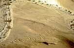
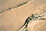
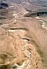
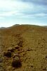
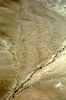
On the Har Karkom plateau we frequently noticed stone alignments whose purposes were not clear, until in 1993 and 1994 aerial reconnaissance flights were able to view them from a new angle. From the vantage of the air, we identified eighteen geoglyphs - large patterns or figures created in stone alignments or by clearing stones from ground surfaces. The geoglyphs of Har Karkom represent anthropomorphic and zoomorphic figures and a variety of patterns. Several details give clues to their dating. Non-figural geoglyphs in the palaeosoil of the Palaeolithic sanctuary (HK 86B) seem to mark sectors in the area near the sanctuary. Because of the quantity of Upper Palaeolithic flint implements, it may be postulated that the geoglyphs belong to the same age as the sanctuary. Near the "Midianite temple", site HK 24, two figures of bovines, made with pebbles, each about thirty meters long, have been attributed to the early Bronze Age. In the same area there is the Bronze Age small sanctuary and some basements of huts from the Palaeolithic. Other traces of geoglyphs are found near BAC sites, and one row of stones more than one hundred meters long is found near the Iron Age site HK 173. These various observations seem to indicate the geoglyphs may belong to a range of periods. We again face an enigmatic discovery. Both the function and the date of the majority of these geoglyphs remain uncertain. Pebble alignments that may mark traces of geoglyphs have been noted also in the Arabah Valley, in the Jordanian plateau and elsewhere in the Near Eastern deserts. Probably the making of geoglyphs was a widespread habit but little attention has been given to it. Further, as we have seen at Har Karkom, they may best be discovered from low flights. Sometimes it is very difficult to identify them while walking on them.
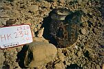
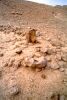
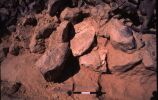
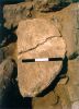
In 1998 a stone tumulus on the eastern border of Har Karkom was excavated by a team led by Valerio Manfredi (site HK 203B). The site is a prominent protrusion of Har Karkom on the edge of the precipice, and its profile can be seen for many kilometres into the reaches of the Paran Desert. The site was believed to be a funerary tumulus, but in the course of excavation and the removal of several cubic meters of stones, only a few atypical flint flakes were found. As the excavation was yielding minimal results, the team asked to interrupt the work. Just as this alternative was being discussed, something strange appeared. At the base of the structure, a fan scraper from the early Bronze Age was found near a black, rectangular monolith, altar-like in form. Nearby a spot of black earth indicated traces of a fire. On top of the rectangular altar stone, Bronze Age men had deposited a white, calcareous, tabular stone which had been intentionally modelled into a semi-circle, sixty centimetres long, eight to ten centimetres thick, and weighing about forty kilograms.
This tumulus serves as a landmark because it can be seen from a great distance. It is likely to be a heap of testimony, a kind of monument the Bible describes as Gal-ed. Such monuments were erected to commemorate an event, as a testimony of an agreement, or as a special dedication (Genesis 31:43-54; Joshua 7:25-26 and 8:28-29). This mysterious tumulus of black stones, assembled to host a white stone intentionally shaped like a crescent moon, seems to have been used as a monument of dedication. The intention may have been to consecrate the mountain to the moon, or rather to the moon god Sin. This Mesopotamic divinity had its main sanctuaries at Ur and Haran, the sites where according to the biblical narration the Hebrew Patriarchs originated.
The possible relation between Har Karkom and the god Sin had already been hypothesised by the rock art expert Rosetta Bastoni on the basis of the quantity of cult rock engravings connected with the ibex, found on the mountain and around it. The ibex, a goat-like species with crescent-shaped horns, which were seen as a symbol of the moon, was the accompanying animal of the god Sin. These numerous scenes of worshipping the ibex emphasise the importance of Sin's lunar cult in the BAC period. Furthermore, an anthropomorphic stone with a vaguely shaped face was found to have the engraving of an ibex on its front which may well be the image of the god Sin. The discovery of the dedicatory monument in 1998 appears to confirm the Bastoni thesis (1997), according to which the name Sinai derived etymologically from the name Sin. Sinai, then, literally signifies "of Sin," thus the biblical term Har Sinai would mean the Mountain of the God Sin.
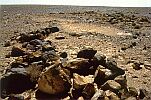
In the field campaign of 1999, among discoveries that still require thorough analysis, one is worth a preliminary mention. A team co-ordinated by Federico Mailland and Sergio Castelletti explored the trails leading to the mountain plateau from the eastern slope. One of these trails, reaching the plateau at the site HK 106, has several cult stations along its route. Spaced four hundred meters apart are two standing stones with a small cleared area, defined by a stone alignment in front of each. An imposing stone circle is part of another group of ceremonial structures along the same trail, along with other structures, like platforms and tumuli, as well as numerous rock engravings representing ibexes. This appears to be a sort of holy path along which ceremonial stations were used for rituals by people ascending from the Paran Desert.
Another such trail, which is the most commonly travelled on the western side of the mountain, leads from site HK 2B to HK 23B; it has along its route rock engravings of worshipers, standing stones, and a "heap of testimony" or gal-ed over an altar. The western trail terminates at a gateway to the plateau, in front of site HK 23B and its circle of seven standing stones. Another ceremonial trail runs from the Paran Desert to the Palaeolithic sanctuary HK 86B. These various roads show a tradition of ceremonial processions while people climbed to the Har Karkom plateau. All these enigmatic discoveries reveal the complexity of performances, rituals, and acts of faith that took place on Har Karkom.
|
 Get the book for only 15. (you save 10.)