| |
BEER KARKOM SITES 400-499
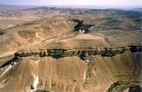
BK/400aCoordinates: 124.2/973.7
Description: Waterhole built with stone wall, almost vertical on 1 side and
oblique on the others. The eastern side, which is the most
circuitous, is stepped and can be easily climbed. Around this
waterhole, which is undoubtedly very old though still in use, are
the remains of several circular, vertical waterholes which are
more recent and none of which are in use today. There are
several oval stone structures around the waterhole, which
probably served as drinking-troughs for animals. There are
Bedouin cemeteries south of the waterhole. 1, which is divided
into 2 sections, is relatively recent, while the other is older. The
2 areas contain different structural typologies. On the western
side, the waterhole leans up against the rocky wall of the
mountain. Above, there are various small rock shelters, which
show vestiges of recent use, including remains of closing walls. 1
cave contained the remains of a human skeleton. Bedouin objects
(jars, remains of leather belts, and tin containers) were found in
abundance. To the north of the waterhole there is an alignment
of stones which leads to a larger boulder fallen from the
mountain; next to it is a "gong" stone entirely covered with
marks of hammering. Upon striking with another stone the
sounds produced can be heard at great distances. As it is located
in a gorge, the echo effect is very impressive. At the foot of the
Gong rock there is a rectangular platform, on it an
anthropomorphic stone and flint implements.
Finds: Abundant flints from the Upper Palaeolithic and BAC periods.
BAC pottery; a few fragments of anomalous pottery that were
not possible to date (perhaps from the Iron Age or the Persian
period?). A large number of sherds dating to Roman-Byzantine
and Islamic times.
Periods MC: UP, BAC, HEL, RBY, ISL.
Site typology:
Bibliography: EA86, p. 312; EA97, p. 67.
BK/400bCoordinates: 124.1/973.6
Description: Vestiges of low walls at the top of the hill which overlooks the
waterhole. A series of 6 small tumuli, and a pillar or standing
stone is aligned along the edge of a hill that overlooks site
BK/450. Numerous small caves and rock shelters. Some of them
have built structures inside, such as walls and storing places.
Site typology:
Bibliography: EA86, p. 312.
BK/400cCoordinates: 124.1/973.8
Description: A tumulus and several heaps of stones.
Site typology:
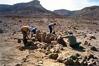
BK/401Coordinates: 123.8/974.4
Description: Remains of a village on a large terrace of the wadi, with 21 stone
structures ordered in 2 aligned series. 1 series is against the
mountain and the other is on a small hill at the center of the
terrace. The structures are homogeneous, and all have a single
room. In addition there are the remains of 2 stone enclosures,
probably intended for livestock, which seem to be older. 10 of
the structures show signs of having been rebuilt and reutilized.
Finds: BAC flints and pottery, and RBY pottery. 1 piece of early glass.
A few anomalous fragments of pottery which have not yet been
dated. Probably either Persian or Hellenistic; Grindstone.
Periods MC: BAC, HEL, RBY.
Site typology:
Bibliography: EA86, p. 312.
BK/401bCoordinates: 123.7/974.5
Description: 2 structures similar to those previously described at site BK/401a
on the opposite side of the wadi. To the west of the structures,
remains of agricultural terracing.
Site typology:
Bibliography: EA86, p. 313.
BK/402Coordinates: 123.4/974.4
Description: Remains of dwelling site with courtyard structures and a few
"threshing-floors" delimited by a series of stones. 3 ensembles of
structures were identified. The settlement seems to have been
developed in the course of its use; in fact, it seems that smaller
structures have been added in a later time around 2 main
courtyard structures. While the material culture is similar to that
found at site BK/401, about 300 m. away, the structures
themselves are completely different. The "threshing-floors"
resemble those discovered in the Uvda valley in the southern
Negev.
Finds: BAC pottery and flint, RBY pottery.
Periods MC: BAC, RBY.
Bibliography: EA86, p. 313; EA97, p. 65.
BK/403Coordinates: 123.4/974.3
Description: Stone tumulus measuring about 4 m. in diameter on the hill
overlooking site BK/402.
Site typology:
Bibliography: EA86, p. 313; EA93a, p. 40.
BK/404Coordinates: 123.0/974.1
Description: Large courtyard structure with at least 3 smaller structures
around it.
Periods MC: BAC.
Site typology:
Bibliography: EA86, p. 313.
BK/404bCoordinates: 122.8/974.0
Description: On the bank of the wadi, near a tree of acacia desertica which
presupposes the presence of water, 5 barrows, and 4 circles are
marked by alignments of stones. The oval barrows are about 2 x
1. 50 m. and are presumably tombs. About 20 m.. apart, there is
another oval circle of stones, probably a hut floor.
Finds: Pottery
Periods MC: RBY, ISL.
Site typology:
BK/405aCoordinates: 123.7/974.4
Description: Remains of a rectangular building with a small tumulus nearby.
Periods MC: RBY, NAB.
Site typology:
Bibliography: EA86, p. 313.
BK/405bCoordinates: 123.8/974.4
Description: Remains of an encampment with 3 structures.
Periods MC: RBY.
Site typology:
Bibliography: EA86, p. 313.
BK/406Coordinates: 123.7/974.2
Description: Remains of an encampment that included 10 structures.
Find: Byzantine pottery.
Periods MC: RBY.
Site typology:
Bibliography: EA86, p. 313.
BK/407aCoordinates: 124.0/974.0
Description: At the top of the hill to the western side of the wadi which
overlooks the waterhole of Beer Karkom (site BK/400) there is a
plateau defended by a surrounding wall in the form of a semi-
circle which ends to the south on the precipice and covers an
area of about 60x40 m. At least 5 circular turrets can be
discerned along the wall which reaches a thickness of 1.7 m.. 2
of the towers are detached from the wall forming entrances
between them and the wall itself. 1 portion of the wall seems to
have dwelling areas along it. In the explored area, this is the
only building that can be defined as having a military and
defensive purpose. The only other possible military structures are
the ones at its base below (site BK/408), likely to defend the
important Maale Sagi trail leading from the waterhole to the
mountains of the central Negev; and site BK/450 located on the
opposite site of Beer Karkom which controls the trail to Beer
Karkom from the South. It is unclear whether this can be
considered a dwelling site or rather an army fortress, which,
however, includes about 10 dwelling units. As concept, it may be
assimilated to the courtyard sites.
Finds: Numerous BAC flints, a few pottery pieces and a fragment of a
small alabaster vase. Fragments of pottery likely to be Iron Age
(?) and Islamic.
Periods MC: BAC, IA?, ISL, UP.
Site typology:
Bibliography: EA86, p. 313; EA88a, p. 114; EA93a, p. 44.
BK/407bCoordinates: 124.2/974.0
Description: On the East Side of the hill of the fort (BK/407), at mid slope,
there is a tumuli in a rock shelter, rocks obstruct the opening. A
skeleton is lying supine with the head to the north and face
turned east. The bones outcropped, and the skeleton does not
seem to be violated. In a small ravine, there is a cache of rocks.
In front of the tombs there is another storeroom with a small
stone wall, which was found open.
Finds: No trace of material culture. In the immediate vicinity a copper
fragment with beaten border has been found, probably ISL.
Site typology:
Periods MC: ISL.
BK/408Coordinates: 123.9/973.9
Description: Remains of a massive square structure (defense tower?) and of 3
minor structures to either side were found in the middle of a
narrow passage of the trail between 2 peaks. Most probably this
was a defensive building related to site BK/407 intended to
protect the passage to the Beer Karkom waterhole. The central
tower is constructed with large uncut stones, each about 1 m.
long; it measures about 5 x 6 m. and has 1 small room.
Finds: BAC flints, BYZ and ISL pottery.
Periods MC: BAC, RBY, ISL.
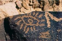
Rock Art: Next to these structures there are engravings on movable rocks,
which do not have patina. 4 of the rocks were removed.
Periods RA: III, IV-A, IV-C.
Site typology:
Bibliography: EA86, p. 313.
BK/409a-bCoordinates: 124.4/973.8
Description: A virtually isolated hill overlooks the wadi east of the Beer
Karkom waterhole, rising above the surroundings by about 200
m.. The view from this hill dominates the great Maale Sagi
caravan trail to the west for more than 2km. From the peak one
can also see Wadi Karkom over a 2km stretch and, southeast of
it, one can dominate a valley which contains abundant remains
of settlements, including site HK/110. This is undoubtedly a
strategic point from which one can control any movement in the
surrounding area. A number of rock shelters are located in the
wadi to north of the site, and reveal traces of recent use. There
are some courtyard structures of the BAC period on this hill
(BK/409 b). On the western side which overlooks the wadi there
are several tumuli as well as a peculiar structure: a large slab of
rock set horizontally like a seat, with 2 stone walls on either
side. Each wall is flanked by a rock with schematic engravings,
which presumably are recent.
Inside of the principal courtyard structure 3 small
anthropomorphic-shaped stones have been found, next to one
another. 2 of those stones show traces of artificial engravings
completing the natural forms. Flint implements BAC thickly
cover the area.
Periods MC: BAC, ISL.
Rock Art: 5 engraved rocks.
Periods RA: IV-A, VI.
Site typology:
Bibliography: EA86, p. 313.
BK/410a-eCoordinates: 124.7/973.7
Description: In the valley east of Beer Karkom there is a large
conglomeration of dwelling sites with stone bases many of which
are courtyard structures. They cover an area measuring about
200 x 100 m.. About 50 of these structures apparently had
"courtyards", while other side rooms are discerned as well.
Simple stone circles better preserved and undoubtedly dating to
more recent times than the others form other structures in the
area. It seems possible to distinguish 2 phases of construction in
the older structures, both of which are associated with BAC
pottery and flints. To the extreme east of the complex and about
50 m. from the last structures there is another aligned series of 8
stone structures with both oval and round plans, related to an
archaic phase of the complex (BK/410 d). Note that the
structural remains reveal 3 different kinds of plans, all 3 related
to BAC material culture. In the wadi north of these sites there
are 3 groups of stone structures similar to those at site BK/410c.
Periods MC: BAC, RBY.
Site typology:
Bibliography: EA86, p. 313.
BK/410f-gCoordinates: 124.8/973.8
Description: A series of 8 structures aligned east west, along the terrace of the
wadi.
Finds: Abundant Roman-Byzantine pottery.
Periods MC: RBY.
Site typology:
Bibliography: EA86, p. 314.
BK/410h-iCoordinates: 124.9/973.8
Description: 2 large stone circles on the southern terrace of the wadi, 100 m.
east of the proceeding site following the wadi upstream. Next to
them is a dwelling structure.
Periods MC: Probably RBY.
Site typology:
Bibliography: EA86, p. 314.
BK/411aCoordinates: 124.5/973.6
Description: Remains of an encampment on a wide terrace of Wadi Karkom,
cut through the middle of a well beaten and presumably more
recent path.
Finds: Roman-Byzantine and Islamic pottery.
Periods MC: RBY, ISL, UP.
Site typology:
BK/411bCoordinates: 124.5/973.5
Description: Remains of an Islamic necropolis.
Periods MC: ISL.
Site typology:
Bibliography: EA86, p. 314.
BK/412a-cCoordinates: 124.6/973.4
Description: The remains of stone structures and small tumuli with pottery
and flints were found on 3 low hills on the eastern side of Wadi
Karkom. On the slope of the hill furthest eastward, a small but
very finely made bifacial hand-axe was found dating to the
Lower Palaeolithic period.
Finds: Lower Palaeolithic flint (Micoquian?), BAC flint and pottery,
Nabatean and Roman-Byzantine pottery, a fragment of worked
palm wood and a fragment of granite mortar, similar to the type
that comes from the granite mountains south of Eilat.
Periods MC: LP, BAC, RBY.
Site typology:
Bibliography: EA86, p. 314.
BK/413aCoordinates: 124.8/973.5
Description: 3 courtyard structures and several heaps of stones on the
northern terrace of the wadi.
Finds: Flints and BAC pottery.
Periods MC: BAC.
Site typology:
Bibliography: EA86, p. 314.
BK/413bCoordinates: 124.9/973.4
Description: 3 stone structures on the southern terrace of the wadi.
Finds: Roman-Byzantine pottery.
Periods MC: RBY.
Site typology:
Bibliography: EA86, p. 314.
BK/414Coordinates: 124.9/973.3
Description: Heaps of stones on a gradual slope.
Finds: Flints dating to the Upper Palaeolithic period. Roman pottery.
Periods MC: UP, RBY.
Site typology:
Bibliography: EA86, p. 314.
BK/415Coordinates: 124.8/973.3
Description: Remains of stone structures on the slope.
Finds: Middle Palaeolithic flints. Pottery.
Periods MC: MP, RBY.
Site typology:
Bibliography: EA86, p. 314.
BK/416Coordinates: 124.7/973.3
Description: 6 stone structures partially covered by alluvial soil. 3 orthostats
(?) on the eastern side.
Finds: Flints and pottery.
Periods MC: BAC, RBY.
Site typology:
Bibliography: EA86, p. 314.
BK/417Coordinates: 124.8/973.2
Description: Remains of at least 3 oval stone structures.
Finds: Flints and pottery.
Periods MC: BAC, RBY.
Site typology:
Bibliography: EA86, p. 314.
BK/417bCoordinates: 125.0/973.2
Description: Remains of recent Bedouin camp; next to it, there is a series of
more ancient agricultural terracing, which has vestiges of
reconstruction.
Finds: Byzantine, Islamic pottery.
Periods MC: RBY, ISL.
Site typology:
Bibliography: EA86, p. 314.
BK/418Coordinates: 125.2/973.0
Description: Remains of at least 3 stone structures.
Finds: Flints and pottery.
Periods MC: BAC, RBY.
Site typology:
Bibliography: EA86, p. 314.
BK/419Coordinates: 125.4/973.0
Description: 2 stone circles and piles of stones on both sides of the wadi
(apparently the wadi divided the village in 2).
Finds: Flints and pottery.
Periods MC: BAC, RBY.
Site typology:
Bibliography: EA86, p. 314.
BK/420a-bCoordinates: 125.5/972.9
Description: In the terrace of the wadi, below the engraved rock, there are
remains of 2 large enclosures and several heaps of stones.
Finds: Flints.
Periods MC: MP.
Rock Art: 1 engraved rock.
Periods RA: VI-VII.
Site typology:
Bibliography: EA86, p. 314.
BK/421Coordinates: 125.4/972.8
Description: A tumulus and a pile of stones on a gradual slope.
Finds: Flints and pottery.
Periods MC: BAC.
Site typology:
Bibliography: EA86, p. 314.
BK/422Coordinates: 125.3/972.8
Description: A stone circle and a stone structure.
Finds: Flints, pottery.
Periods MC: BAC, BYZ.
Site typology:
Bibliography: EA86, p. 315.
BK/423Coordinates: 125.4/972.7
Description: Remains of 3 stone structures; 2 are oval, 1 is V-shaped.
Periods MC: RBY.
Site typology:
Bibliography: EA86, p. 315.
BK/424Coordinates: 125.3/972.6
Description: 3 oval structures and several piles of stones.
Finds: Pottery.
Periods MC: RBY.
Site typology:
Bibliography: EA86, p. 315.
BK/425Coordinates: 125.0/972.6
Description: 3 stone circles with a tumulus next to each other on the summit
of a hill, which from the north overlooks a bend in the wadi.
Another stone circle at the foot of the hill in the wadi itself, 60
m. from the previously described group. Continuing downward
in the wadi, remains of agricultural terracing.
Finds: Flints and pottery.
Periods MC: UP, RBY.
Site typology:
Bibliography: EA86, p. 315.
BK/426Coordinates: 124.6/972. 6
Description: 3 circular, paved platforms, and the remains of a 4th which is
circular on 1 side and angular on the other. 2 of the platforms
are in a perfect state of preservation; each platform has a
structure facing east, presumably an altar. East of this complex
are remains of motifs made with pebbles on the ground (pebble
drawings), 2 of which, represent gazelles measuring about 1 m.
in length.
Finds: Flint and pottery.
Periods MC: BAC.
Site typology:
Bibliography: EA86, p. 315; EA97, p. 66.
BK/426bCoordinates: 124.7/972.7
Description: A tumulus and around it a cromlech. On the tumulus itself there
is an oblong rock with an inscription (Nabatean?), which was,
presumably, intended to be fixed in a vertically upright position.
Nearby there are a few stones showing naturally
anthropomorphic shapes, 2 of them have been fixed to the
round and are standing up.
Bibliography: EA86, p. 315.
BK/427Coordinates: 124.5/972.6
Description: Settlement to the west of the altar-platforms, measuring 80 x 60
m. with 7 dwelling structures, a number of enclosures and
several minor buildings. It extends 50 m. from the platform to
the foot of the overlooking hill.
Finds: Flints and pottery.
Periods MC: LP, BAC, RBY.
Site typology:
Bibliography: EA86, p. 315; EA97, p. 66.
BK/428a-bCoordinates: 124.6/973.1
Description: Remains of a cemetery. 80 m. south, on both sides of a lateral
wadi, additional heaps of stones.
Finds: Nabataean, Byzantine and Islamic pottery. Flints dating to the
Lower Palaeolithic period, including 2 bifacial hand- axes.
Periods MC: LP, RBY, ISL.
Site typology:
Bibliography: EA86, p. 315.
BK/429Coordinates: 124.8/972.8
Description: Remains of a village on the terrace in a bend of the wadi; they
include sweven circular stone dwelling units and an enclosure,
presumably for livestock. This seems to be older and shows
vestiges of reuse in the Roman-Byzantine period. In between 2 of
the structures, there is a group of standing stones. In the vicinity,
there is a large tumulus and a few smaller tumuli.
Finds: Pottery.
Periods MC: RBY.
Site typology:
Bibliography: EA86, p. 315.
BK/430a-eCoordinates: 124.6/972.4
Description: Large stone circle along the wadi with a tumulus at the center
and several courtyard structures. Various other stone structures
remain within a radius of 150 m..
At least 9 tumuli; the architectural evidence indicates this site
was utilized in different periods and some of the walls were
rebuilt more than once.
Finds: Flints and pottery.
Periods MC: BAC, RBY.
Site typology:
Bibliography: EA86, p. 315.
BK/431Coordinates: 124.8/972.4
Description: A thick level of ashes by the side of the bed of the wadi begins
10cm beneath the current ground level and reveals the presence
of a prolonged fire, perhaps not very old. On the terrace above
some 50 m. away, a stone circle, 2 m. in diameter, and a small
pile of stones.
Finds: Flints and pottery.
Periods MC: BAC?, RBY.
Site typology:
Bibliography: EA86, p. 315.
BK/432Coordinates: 125.0/972.3
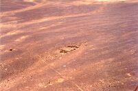
Description: 3 courtyard structures, 2 of which are built with very large
stones; an elongated oval enclosure along the wadi (about 18 m.
long).
Finds: BAC flints and pottery. Roman-Byzantine pottery. A marine
shell from the Red Sea.
Periods MC: BAC, RBY.
Site typology:
Bibliography: EA86, p. 315.
BK/432bCoordinates: 125.0/972.4
Description: A complex ensemble of dwelling structures with a large
enclosure for livestock.
Periods MC: RBY.
Site typology:
Bibliography: EA86, p. 315.
BK/433Coordinates: 125.1/972.3
Description: Remains of a camping site with the basement of at least 4 stone-
built structures.
Periods MC: BAC, RBY, ISL.
Site typology:
Bibliography: EA86, p. 315.
BK/433bCoordinates: 125.1/972.3
Description: A large BAC courtyard structure, 60 m. west of site BK/433, on
an overlooking plateau.
Periods MC: BAC.
Rock art: 1 small isolated rock engraved with the figure of an ibex.
Periods RA: IV-A.
Site typology:
Bibliography: EA86, p. 315.
BK/434a-bCoordinates: 125.1/972.1
Description: 100 m further up along the path, remains of a stone built
enclosure on the edge of a cliff.
Finds: Middle Palaeolithic flints.
Periods MC: MP, BAC.
Rock Art: Engravings along the path to the mountain.
Site typology:
Periods RA: VI-VII.
Bibliography: EA86, p. 315.
BK/435Coordinates: 125.1/972.5
Description: Remains of 4 oval structures on a terrace of the wadi; each has a
courtyard or threshing-floor next to it. Signs of reconstruction
reveal at least 2 distinct phases of human occupation. To the
south, a group of tumuli.
Periods MC: BAC, RBY.
Site typology:
Bibliography: EA86, p. 316.
BK/436Coordinates: 125.2/972.4
Description: Enclosure built at the foot of a hill with uncut black stones,
presumably for livestock. A group of large stones put together by
man has an end stone with a naturally shaped anthropomorphic
face.
Periods MC: RBY.
Rock Art: Engraved rock within the enclosure itself and 2 engraved rocks
on the peak of the hill overlooking the area. 1 early Arabic in-
scription.
Periods RA: IV-C.
Site typology:
Bibliography: EA86, p. 316.
BK/437aCoordinates: 125.5/972.5
Description: Large courtyard structure of oval shape and remains of several
walls around it.
Periods MC: BAC.
Site typology:
Bibliography: EA86, p. 316.
BK/437bCoordinates: 125.5/972.6
Description: Remains of a stone-built enclosure.
Site typology:
BK/438Coordinates: 125.4/972.4
Description: Large stone-built enclosure and some standing stones.
Site typology:
Bibliography: EA86, p. 316.
BK/439Coordinates: 125.4/972.3
Description: 2 large stone circles, on the top of a hill, with a passageway built
between them.
Site typology:
Bibliography: EA86, p. 316.
BK/440Coordinates: 125.3/972.2
Description: On the southern side of the wadi there are 3 large boulders,
apparently intentionally arranged. 2 of these have a naturally
elongated shape and lean against the side of the mountain; be-
tween them there is a smaller rock whose natural shape
resembles an anthropomorphic face. In front of this ensemble
there is a small natural terrace with piles of stones and the
remains of a low wall. It appears that there are also the remains
of a large hearth, because the rocks around it reveal distinct
signs of burning.
Site typology:
Bibliography: EA86, p. 316.
BK/441Coordinates: 124.9/972.0
Description: Remains of an enclosure for livestock.
Periods MC: RBY.
Site typology:
Bibliography: EA86, p. 316.
BK/442Coordinates: 124.8/971.9
Description: Remains of a village with stone structures, 3 of which are over 8
x 7 m. in size; apparently they were dwelling units. Several
minor structures include 1 which may have been an oven. 2 more
stone structures, on the other side of the wadi.
Periods MC: RBY.
Rock Art: 1 engraved rock 50 m. north, on the other side of the wadi.
Periods RA: IV-C, V, VI?.
Site typology:
Bibliography: EA86, p. 316.
BK/443a-bCoordinates: 124.8/972.0
Description: Remains of agricultural terraces on the bank of the wadi and 2
stone-built living structures. On the opposite side of the wadi,
several heaps of stones may indicate the location of a cemetery.
Periods MC: RBY.
Site typology:
Bibliography: EA86, p. 316.
BK/444Coordinates: 124.7/972.2
Description: 4 courtyard structures, 1 in a lateral wadi. 2 of these structures
are spiral in shape. A tumulus at the center of one.
Site typology:
Bibliography: EA86, p. 316.
BK/445Coordinates: 124.4/972.5
Description: Remains of stone structures at the confluence of a lateral wadi
and Wadi Karkom.
Finds: Arabic Pottery.
Periods MC: RBY.
Site typology:
Bibliography: EA86, p. 316.
BK/446aCoordinates: 124 5/974.4
Description: 4 stone structures in alignment, along a terrace of the wadi.
Periods MC: RBY.
Site typology:
Bibliography: EA86, p. 316.
BK/446bCoordinates: 124.4/974.4
Description: A courtyard structure and another smaller structure nearby.
Remains of 2 heaps of stones and a stone circle. Further above, a
rock shelter, which contains the remains of a recent hearth and
walls covered by charcoal soot.
Periods MC: BAC.
Site typology:
Bibliography: EA86, p. 316.
BK/446cCoordinates: 124.4/974.3
Description: On the mountain's side, many natural small rock shelters with
traces of the Islamic age. In 1 of them a hearth. 2 of the shelters
are defined by terracing walls.
Finds: Pottery Gaza type.
Periods MC: ISL.
Site typology:
BK/446dCoordinates: 124.4/974.1
Description: On the mountainside, some rock shelters with Islamic traces. In
2 of them, stone walls with square windows. Probable troglodyte
habitations of Islamic age.
Finds: Pottery Gaza type.
Periods MC: ISL.
Site typology:
BK/446eCoordinates: 124.4/974.0
Description: Along a lateral wadi, several rock shelters with traces of use. 1 of
them faces Har Karkom.
Finds: Hellenistic and Roman pottery.
Periods MC: HEL, RBY.
Site typology:
BK/446fCoordinates: 124.5/974.4
Description: On a tableland, remains of 7 stone barrows.
Finds: Pottery and flints BAC.
Periods MC: AC.
Site typology:
BK/446gCoordinates: 124.4/974.4
Description: Natural shelter with remains of a storeroom built with a stone
and mud wall.
Periods MC: ISL.
Site typology:
BK/446hCoordinates: 124.5/974.3
Description: Large shelter measuring about 20 x3 m.. Remains of a storeroom
built with stone and mud. In front a hearth and at its side, a
stone built pen.
Periods MC: ISL.
Site typology:
BK/447aCoordinates: 123.6/973.5
Description: Remains of a village with about 30 oval structures, on a long
terrace at the confluence of 2 wadis. Another 5 structures of the
same kind on the terrace to the west, on the other bank of the
wadi. Remains of agricultural terracing in the wadi bed.
Finds: Flints and pottery. A bronze spatula with an Arabic inscription.
Periods MC: BAC?, RBY, ISL.
Site typology:
Bibliography: EA86, p. 316.
BK/447bCoordinates: 123.5/973.4
Description: A courtyard structure on a hill on the western bank of the wadi.
Periods MC: BAC.
Site typology:
Bibliography: EA86, p. 316.
BK/448Coordinates: 123.5/973.5
Description: Remains of a courtyard structure on a small hill from which 1
commands the view to the north.
Periods MC: BAC.
Site typology:
Bibliography: EA86, p. 316.
BK449Coordinates: 123.6/973.4
Description: 7 stone structures and several tumuli on the terrace of a wadi. On
the hill above, heaps of stones.
Periods MC: BAC.
Site typology:
Bibliography: EA86, p. 316.
BK/449bCoordinates: 123.7/973.4
Description: 2 stone structures, several tumuli and agricultural terracing on
the bed of the wadi.
Periods MC: RBY.
Site typology:
BK/450aCoordinates: 124.3/973.5
Description: Massive rectangular structure on a hill, perhaps for defensive
purposes, dominates the access to the waterhole from the south.
Apparently associated with the defensive system at sites BK/407
and BK/408, it includes a main building and the remains of 2
small towers on the mountain slope westward. A beaten trail
transverses the site and the main stone structure is in the middle
of that trail, while the 2 towers are on both sides.
Finds: Flints and pottery.
Periods MC: MP, UP, BAC, RBY, ISL.
Site typology:
Bibliography: EA86, p. 316.
BK/450bCoordinates: 124.3/973.6
Description: Bedouin cemetery.
Finds: A large stone pestle next to 1 of the graves.
Periods MC: ISL.
Site typology:
Bibliography: EA86, p. 317.
BK/450cCoordinates: 124.3/973.6
Description: 50 m west of HK/450b, some small rock shelters 2 are protected
by stone-built walls.
Finds: Pottery ISL, wooden utensil of recent making.
Site typology:
BK/451Coordinates: 124.4/973.3
Description: Two large boulders, which had fallen from the mountain,
surrounded by intentionally, placed piles of stones. 1 of these
boulders has a peculiar natural shape, which resembles an
anthropomorphic face. Another boulder has a circle of small
stones surrounding it at a radius of about 4 m.. Several stones
with natural anthropomorphic shapes seem to have been brought
there intentionally.
Finds: Flints and pottery sherds.
Periods MC: UP, BAC.
Site typology:
Bibliography : EA86, p. 317; EA87, p. 28 & 29.
BK/452Coordinates: 124.2/973.4
Description: Group of tumuli on a hilltop which overlooks the Beer Karkom
waterhole from the south.
Periods MC: BAC?.
Site typology:
Bibliography: EA86, p. 317.
BK/453aCoordinates: 124.3/973.2
Description: Piles of stones and several tumuli along a side terrace of the
wadi.
Finds: Flints and pottery. Several fragments of anomalous pottery may
date to the Iron Age.
Periods MC: BAC, IA?, RBY.
Site typology:
Bibliography: EA86, p. 317.
BK/453bCoordinates: 124.0/973.2
Description: Group of tumuli on a hilltop.
Periods MC: BAC?.
Site typology:
Bibliography: EA86, p. 317.
BK/453c
Coordinates: 124.1/973.2
Description: Group of tumuli on a hilltop.
Periods MC: BAC?.
Site typology:
Bibliography: EA86, p. 317.
BK/454aCoordinates: 124.2/972.7
Description: A tumulus and several heaps of stones.
Finds: Flints.
Periods MC: BAC.
Site typology:
Bibliography: EA86, p. 317.
BK/454bCoordinates: 124.3/972.6
Description: Remains of a camping site with at least 30 basements of stone
structures. The structures are organized in rows, 3 of which count
respectively, 9, 7 and 7 structures. Further south a water hole
which has been cleaned recently and a Bedouin cemetery.
Site typology:
BK/455Coordinates: 124.1/972.8
Description: Tumuli on the slope of a hill which overlooks a small wadi.
Perhaps remains of an enclosure.
Finds: Flints.
Periods MC: MP.
Site typology:
Bibliography : EA86, p. 317.
BK/456Coordinates: 124.1/972.5
Description: A circle made of small stones surrounds a large boulder which
had fallen from the mountain. The natural shape of the boulder
has grotesquely anthropomorphic features on both sides. 15 m.
north there is another boulder with anthropomorphic features.
Finds: Flints.
Periods MC: MP.
Site typology:
Bibliography: EA86, p. 317.
BK/457aCoordinates: 123.7/972.3
Description: Numerous piles of stones and flints cover a low hill which ex-
tends from the west toward Wadi Karkom. North, remains of a
Bedouin camp.
Finds: Flints, pottery.
Periods MC: MP, BAC, RBY.
Site typology:
Bibliography: EA86, p. 317.
BK/457bCoordinates: 123.7/972.4
Description: On a gentle slope between 2 wadis, a plaza site composed of 12
stone structures of various dimensions. Eastward, there is a
rounded row of 7-8 stone-built structures which together form a
sort of tail.
Periods MC: BAC.
Site typology:
Bibliography: EA86, p. 317.
BK/457cCoordinates: 123.8/972.4
Description: Remains of 6 stone structures on both sides of the wadi and
several heaps of stones. 5 of the structures are aligned on the
north side of the wadi, while 1 on the opposite side is rounded
and has an almost rectangular courtyard in front of it. A tumulus
exists on the hill above.
Finds: Flints.
Periods MC: RBY.
Site typology:
Bibliography: EA86, p. 317.
BK/457dCoordinates: 123.7/972.5
Description: On the wadi terrace north of site BK/457c, remains of several
stone structures from 2 different periods. The better-preserved
ones are rectangular in shape, while the others are circular.
Several of them show remains of hearths.
Periods MC: BAC, RBY, ISL.
Site typology:
BK/457eCoordinates: 123.7/972.5
Description: Flint atelier on the top of the hill, behind site BK/457 c.
Finds: Cores and blades. 1 Lower Palaeolithic hand-axe.
Periods MC: LP, MP, BAC.
Site typology:
Bibliography: EA87, p. 165.
BK/457fCoordinates: 123.7/972.6
Description: In a small valley north of site BK/457e, a rounded row of 7 stone-
built structures and several additional heaps of stones. Below
them in the lowest part of the small valley, a line of 3 structures
possessing remains of very hot fires was noted inside and outside.
They are likely to have been ateliers in which some substance had
been burned to the point of dissolving stones.
Finds: Numerous flint hammering tools concentrated near the atelier-
like structures.
Flint implements spread all over.
Periods MC: MP, BAC.
Site typology:
BK/458Coordinates: 123.2/972.1
Description: Bases of stone structures and several heaps of stones which seem
to represent different periods. There are at least 3 different kinds
of structures. 6 round structures are along the wadi; above there
is a larger, rounded enclosure; on the slope there are several
smaller, temporary structures which seem to be more recent.
Finds: Flints, pottery.
Periods MC: MP, BAC, RBY, ISL.
Site typology:
Bibliography: EA86, p. 317.
BK/459Coordinates: 123.6/972.3
Description: Tumuli and courtyard structures.
Finds: Flints, pottery.
Periods MC: MP, BAC.
Site typology:
Bibliography: EA86, p. 317.
BK/460Coordinates: 123.4/972.0
Description: Tumuli and piles of stones. Remains of agricultural terracing.
Site typology:
Bibliography: EA86, p. 317.
BK/461Coordinates: 123.6/972.0
Description: Tumuli and piles of stones.
Site typology:
Bibliography: EA86, p. 317.
BK/462Coordinates: 123.3/971.8
Description: A large site along a tributary of Wadi Karkom. Courtyard struc-
tures and bases of stone structures. A small stone circle next to an
alignment of 5 stele. Circular platforms with alter. Large
enclosure. Remains of horizontal straight alignments of stones
which could have been agricultural terraces.
Finds: Flints, pottery.
Periods MC: MP, BAC, NAB, RBY.
Site typology:
Bibliography: EA86, p. 317.
BK/463aCoordinates: 123.4/971.7
Description: Remains of a settlement of significant dimensions. 2 paved plat-
forms with altar to the eastern side and another 3 smaller circular
platforms. Oval and elongated structures aligned in series. Large
enclosure and various stone circles. North, an enclosure whose
condition indicates it is much older than the other structures. At
least 4 stones with anthropomorphic features.
Finds: Flints and pottery.
Periods MC: MP, NEO?, BAC, RBY.
Site typology:
Bibliography: EA86, p. 317.
BK/463b-cCoordinates: 123.4/971.8
Description: Remains of an ancient encampment with a series of 9 structures.
Adjacent to this site eastward, vestiges of a Bedouin encampment
(site BK/463 c).
Finds: Pottery. Large stone pestle.
Periods MC: BAC, RBY, ISL.
Site typology:
Bibliography: EA86, p. 318.
BK/464Coordinates: 123.3/971.7
Description: Remains of 4 major stone structures and several smaller ones,
including stone circles and tumuli.
Finds: Pottery.
Periods MC: BY.
Site typology:
Bibliography: EA86, p. 318.
BK/464bCoordinates: 123.4/971.7
Description: Several piles of stones and 2 stone circles.
Finds: Flints.
Periods MC: MP, BAC.
Site typology:
Bibliography: EA86, p. 318.
BK/465Coordinates: 123.6/971.5
Description: Piles of stones.
Finds: Flint, pottery.
Periods MC: MP, BAC, RBY.
Site typology:
Bibliography: EA86, p. 318.
BK/466Coordinates: 122.6/972.2
Description: Remains of 2 circular, adjacent structures, each of which
measures about 2 m. in diameter.
Finds: Flint, pottery.
Periods MC: MP, BAC.
Site typology:
Bibliography: EA86, p. 318.
BK/467a-cCoordinates: 122.5/972.8
Description: Remains of a large enclosure and several tumuli. South, several
heaps of stones on the slope (site BK/467 b). North, at least 2
groups of heaps of stones (site BK/467 c).
The entire area appears to have been used by human groups
during different periods.
Finds: Flints.
Periods MC: BAC.
Site typology:
Bibliography: EA86, p. 318.
BK/468Coordinates: 122.4/971.8
Description: 1 paved platform (6 x 9 m.) and a smaller elevated stone circle;
next to them, other structures.
Finds: Flints and pottery.
Periods MC: BAC, RBY.
Site typology:
Bibliography: EA86, p. 318.
BK/469Coordinates: 122.4/971.7
Description: Remains of an elliptical structure; circles and piles of stones.
Finds: Flint, pottery.
Periods MC: BAC, RBY.
Site typology:
Bibliography: EA86, p. 318.
BK/470Coordinates: 122.5/971.5
Description: Remains of heaps of stones and structures.
Finds: Flint, pottery.
Periods MC: MP, BAC, RBY.
Site typology:
Bibliography: EA86, p. 318.
BK/471aCoordinates: 122.8/971.6
Description: Remains of 4 stone structures on a terrace of the wadi, with
evident signs of reconstruction and reutilization at different
stages.
Periods MC: RBY.
Site typology:
Bibliography: EA86, p. 318.
BK/471bCoordinates: 122.8/971.6
Description: Several piles of stones on a low hill on the other side of the wadi,
as well as various fairly ruined structures. Probably the remains
of a short-term encampment.
Finds: Unusual Pottery not found elsewhere in the area of HK or BK.
Perhaps fragments dating to the Hellenistic period.
Periods MC: HEL?.
Site typology:
Bibliography: EA86, p. 318.
BK/471cCoordinates: 122.7/971.6
Description: 2 rectangular structures.
Periods MC: RBY.
Site typology:
Bibliography: EA86, p. 318.
BK/471dCoordinates: 122.9/971.6
Description: 2 rectangular structures and agricultural terracing.
Periods MC: RBY.
Site typology:
Bibliography: EA86, p. 318.
BK/472a-bCoordinates: 122.6/971.7
Description: 2 tumuli on the peak of a mountain. On the eastern slope, 3 hut
floors (site BK/472 b).
Finds: Flints.
Periods MC: BAC.
Site typology:
Bibliography: EA86, p. 318.
BK/473a-bCoordinates: 122.9/971.9
Description: Remains of 2 main stone structures and a few heaps of stones on
the northern terrace of the wadi. North, a stone circle. 50 m.
further north, 2 rectangular enclosures. (site BK/473b ).
Periods MC: RBY.
Site typology:
BK/474a-cCoordinates: 122.8/972.0
Description: 15 stone structures, mostly rectangular, at the confluence of 2
wadis. 10 of them have remains of well-built walls and appear to
be dwelling units. They are organized in 3 rows of respectively
4, 3 and 3 structures.
South, on the opposite side of the wadi, an isolated structure and
alignments of stones (site BK/474 b).
North of the wadi, an area covered by small heaps of stones
appears to be a Bedouin cemetery.
Periods MC: ISL, RBY.
Site typology:
Bibliography: EA86, p. 318.
BK/475a-bCoordinates: 122.7/972.1
Description: Remains of a cluster of enclosures surrounded by dwelling units
around. This is a typical pastoral site, which must have involved
a large number of animals lead by few families.
On the opposite side of the wadi northward, an isolated rounded
structure (site BK/475 b).
Periods MC: RBY.
Site typology:
Bibliography: EA86, p. 318.
BK/476Coordinates: 123.0/971.8
Description: Remains of agricultural terracing. Several heaps of stones, which
indicate the location of a temporary camping, site.
Finds: Fragment of a grinding stone.
Periods MC: RBY.
Site typology:
Bibliography: EA86, p. 318.
BK/477a-cCoordinates: 123.1/971.8
Description: Remains of 6 rectangular and 2 oval structures; agricultural terracing.
50 m. south, on both sides of the wadi, 6 stone built structures some
of them appearing very old and 2 of them having been rebuilt
probably in Byzantine times (site (BK/477b). Several heaps of
stones arranged in a semicircle (site BK/477 c).
Periods MC: RBY.
Site typology:
Bibliography: EA86, p. 318.
BK/478Coordinates: 123.1/972.0
Description: 8 small stone structures form a circle which measures about 35
m. in diameter. The inner circle appears as having been cleared
of stones. West, 2 tumuli and several heaps of stones. About 40
m. east, remains of 2 stone circles.
Finds: Numerous BAC flints. A small copper disk with 8 small circles,
w hich seem to replicate the plan of the BAC settlement.
Period MC: BAC.
Site typology:
Bibliography: EA86, p. 319; EA87, p. 28, 29, & 179; AF95, p. 9.
BK/479Coordinates: 123.2/971.7
Description: Several tombs and standing stones or menhirs.
Finds: Pottery.
Periods MC: HEL, RBY.
Rock Art: At least 3 engraved rocks, 1 of which has an early Arabic
inscription.
Periods RA: IV-C.
Site typology:
Bibliography: EA86, p. 319.
BK/480a-bCoordinates: 123.1/971.3
Description: Remains of stone structures, most of which are round and oval,
extend over an area of 300 x 100 m.. Over 100 structures were
counted. This is one of the largest settlements found in the entire
area under exploration. 2 large circles and several low walls at
the edge of the settlement, partly anomalous in type.
On the western side a burial area with heaps of stones.
On the top of 3 hills south, east, and north of the site, there are
isolated stone structures, which may have been watchtowers (site
BK/480 b).
Superimposition of different periods.
Finds: Abundant pottery could date to Persian or Hellenistic times. At 2
locations there is also Roman-Byzantine pottery.
Periods MC: HEL, RBY.
Site typology:
Bibliography: EA86, p. 319; EA88a, p. 116; EA93a, p. 55.
BK/481a-bCoordinates: 123.2/971.2
Description: Remains of stone structures and an enclosure. 50 m. further
south, remains of a temporary encampment (site BK/481 b).
Finds: Abundant BAC flints, RBY and ISL pottery, and an LP bifacial
hand-axe. A group of 4 rocks having naturally anthropomorphic
shapes seem to have been collected and placed there by man.
Periods MC: LP, BAC, HEL, RBY, ISL.
Site typology:
Bibliography: EA86, p. 319.
BK/482Coordinates: 123.8/971.2
Description: Large circle and structure, whose purpose is most likely to collect
water. Perhaps the remains of an ancient waterhole. Vestiges of
agricultural terracing.
Periods MC: BAC, RBY, ISL.
Site typology:
Bibliography: EA86, p. 319.
BK/483aCoordinates: 123.5/970.7
Description: Remains of a stone enclosure, and a Bedouin camping site.
Periods MC: NAB, RBY.
Site typology:
Bibliography: EA86, p. 319.
BK/483bCoordinates: 123.6/970.7
Description: 3 tumuli on the hill 652.
Site typology:
BK/484Coordinates: 123.8/970.8
Description: Remains of an encampment. 6 locations, surrounded by stones
that were removed from the inner area, may indicate the original
localities of Bedouin tents.
Periods MC: ISL.
Site typology:
Bibliography: EA86, p. 319.
BK/485Coordinates: 122.5/970.7
Description: Remains of 3 oval stone structures on a plateau that commands a
good view to the valley.
Finds: Pottery of undefined type (HEL?).
Periods MC: HEL?.
Site typology:
Bibliography: EA86, p. 319.
BK/486Coordinates: 126.4/972.3
Description: Remains of 2 enclosures, presumably for livestock, and of 3 small
heaps of stones on the terrace of the wadi. Further down along
the wadi eastward, remains of 5 circular stone structures.
Periods MC: RBY.
Site typology:
Bibliography: EA86, p. 319.
BK/487Coordinates: 126.5/972.4
Description: Enclosure for livestock.
Periods MC: ISL.
Site typology:
Bibliography: EA86, p. 319.
BK/488Coordinates: 126.5/972.7
Description: Enclosure for livestock near some heaps of stones, which may
indicate the location of a dwelling unit. A small rock shelter
shows marks of having been used by man. 50 m. further north,
remains of a camping site (Bedouin?).
Periods MC: RBY, ISL?.
Site typology:
Bibliography: EA86, p. 319.
BK/489Coordinates: 126.3/973.2
Description: Remains of a nomadic encampment, probably quite ancient. A
large enclosure possibly for livestock was discerned.
Periods MC: RBY.
Site typology:
Bibliography: EA86, p. 319.
BK/490Coordinates: 126.1/973.8
Description: Remains of a nomadic encampment, which is not very recent. An
enclosure for livestock and several heaps of stones.
Periods MC: ISL.
Site typology:
Bibliography: EA86, p. 319.
BK/491Coordinates: 122.2/970.3
Description: Remains of agricultural terracing.
Finds: Flints and pottery.
Periods MC: UP, RBY.
Site typology:
Bibliography: EA86, p. 319.
BK/492aCoordinates: 122.2/970.6
Description: Remains of 7 stone Description: 3 are rectangular and 4 are
circular. They reflect 2 different phases of settlement. The rec-
tangular structures are better preserved, and are undoubtedly later
in date than the others.
Finds: Pottery.
Periods MC: RBY.
Site typology:
Bibliography: EA86, p. 319.
BK/492bCoordinates: 121.9/970.7
Description: Remains of a Bedouin encampment.
Periods MC: ISL.
Site typology:
BK/493Coordinates: 122.3/970.8
Finds: Flints.
Periods MC: UP.
Site typology:
Bibliography: EA86, p. 319.
BK/494a-cCoordinates: 121. 4/971. 3
Description: An enclosure, 3 living structures, 1 tumulus BAC and several
heaps of stones, spread across 2 small hills. 50 m.. east, on the
terraces of the overhanging wadi, there are 2 enclosures which
are built differently. They seem likely to be RBY and presumably
have been reused in Islamic times. On 1 of the hills there is a
tumulus and remains of walls. The site is near a pass along an
ancient trail.
Periods MC: UP, MP, BAC, ISL.
Site typology:
Bibliography: EA86, p. 319.
BK/495Coordinates: 122.2/971.8
Description: 8 rectangular structures along the terrace of the wadi. Further
above, on the upper terraces, there are remains of stone align-
ments which may have been an enclosure.
Site typology:
Bibliography: EA86, p. 320.
BK/496Coordinates: 122.1/971.9
Description: Remains of low walls and piles of stones on a large entrenched
terrace at a hairpin turn of the wadi. Bedouins evidently used
several structures.
Site typology:
Bibliography: EA86, p. 320.
BK/497a-bCoordinates: 121.9/972.0
Description: Remains of a large settlement stretching over an area of about
120 m., over 2 terraces of the wadi. On the upper terrace, there is
a large circular enclosure and further east, 3 more large
structures, which seem to be animal enclosures. On the lower
terrace, remains of at least 5 rectangular structures.
On the opposite side of the wadi southward, there are remains of
at least 7 other rectangular living structures.
This site undoubtedly represents different periods.
Periods MC: BAC, RBY.
Site typology:
Bibliography: EA86, p. 320.
BK/498a-bCoordinates: 121.5/972.0
Description: 2 rectangular structures. On the opposite side of the wadi there
are the remains of another similar structure and perhaps the
vestiges of a terrace. On the terrace above, a group of 5 structures
and several heaps of stones are organized to form a semicircle
(site BK/498 b).
Periods MC: RBY.
Site typology:
Bibliography: EA86, p. 320.
BK/499Coordinates: 121.1/972.3
Description: Remains of a small village occupied in 2 different phases. On the
upper terrace of the wadi are 2 BAC courtyard structures and a
long wall, which may have been part of a very large enclosure.
On the lower terrace are 5 oval structures, much better preserved
and more recent.
Periods MC: BAC, RBY.
Site typology:
Bibliography: EA86, p. 320.
|
 Get the book for only 15. (you save 10.)